The State of the Climate report, published each year as a supplement to the Bulletin of the American Meteorological Society, is the most comprehensive annual global climate report, with contributions from hundreds of authors worldwide. The newly released State of the Climate in 2024 details record global greenhouse gas concentrations and surface temperatures as well as other key trends, events, and phenomena.
In this post, we speak with Tropics chapter co-editor Carl Schreck about tropical oceans and storms in 2024. Read the Tropics chapter here [PDF].
What was your role in the report?
This was my tenth year serving as co-editor of the Tropics chapter, and I co-author several sections. This year, I also wrote a sidebar on Hurricane Helene, having experienced it firsthand here in Asheville.
What are some noteworthy trends or events you’d want to highlight from the Tropics in 2024?
The Pacific transitioned from a strong El Niño in 2023 to a mixed state at the end of 2024 where the ocean was ENSO-neutral, but the atmosphere was behaving more like La Niña. This mix of neutral and La Niña conditions made it more challenging than normal to explain some of the other patterns we saw in 2024.
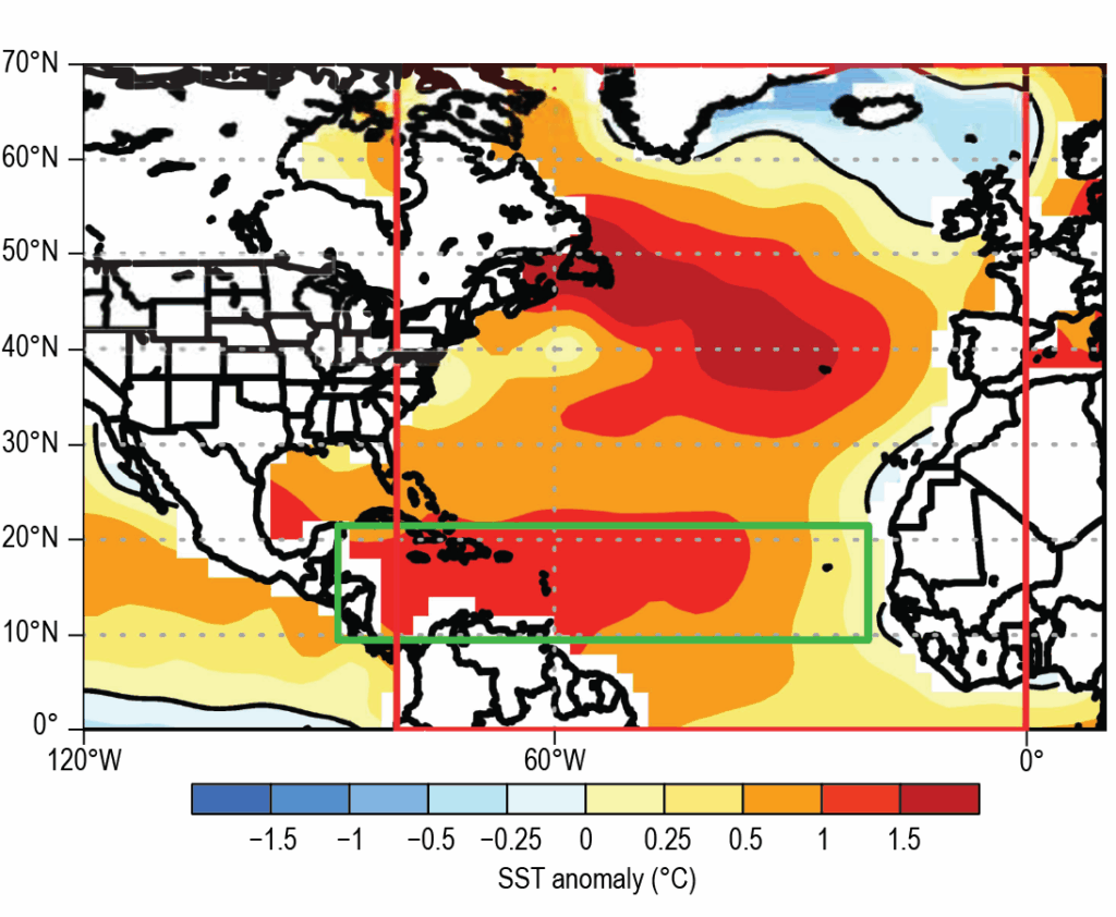
Image: Sea-surface temperature anomalies (°C) in August–October 2024 in the main development region (MDR; green box) and the North Atlantic (red box). Anomalies are departures from the 1991–2020 period means. (Fig. 4.24. (a) from “The Tropics” chapter of The State of the Climate in 2024; see report for full caption and explanation.)
The Atlantic hurricane season was very unusual in 2024. The Atlantic main development region was hot—2024 was the second hottest on record, behind only 2023, and was about 1°F above the next closest year. That combined with La Niña-ish conditions in the Pacific typically favors a very active hurricane season.
The season began in record-breaking fashion with Hurricane Beryl in June—the earliest Category 5 hurricane in history—but then it turned quiet. No storms were active during the climatological ramp up of the season (August 20-September 9). The season didn’t really get going until Hurricane Helene at the end of September, and then it stayed active the rest of the way through, including Hurricane Milton.
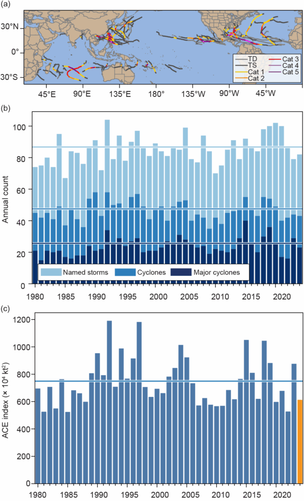
The West Pacific was the 15th quietest in the last 80 years in terms of accumulated cyclone energy—a measure of the strength, duration, and frequency of tropical cyclones. It tends to be quieter during La Niña years, but the West Pacific has been quieter than normal for four of the last five years.
Image: (a) Global summary of tropical cyclone (TC) tracks for the 2024 season; (b) global TC counts; and (c) global accumulated cyclone energy (ACE) values (× 104 kt2). Horizontal lines in (b) and (c) are the 1991–2020 normal values. (Fig. 4.21. from “The Tropics” chapter of The State of the Climate in 2024; see report for full caption and explanation).
What was your experience with Hurricane Helene?
I live in Asheville, and my office is co-located with NOAA’s National Centers for Environmental Information. My colleagues and I were directly affected by Hurricane Helene. In the sidebar, I talk about the CoCoRaHS rainfall observations that I took at my house during the storm—unexpected field work! In the first 18 hours, I had 6.5″ of rain, which was almost double the previous record at my house for the last 12 years. And the hurricane was still down near Cuba at that time. The rain was from a predecessor rainfall event (PRE): a cold front and the mountains in our region would’ve made it rain anyway, but that rain was supercharged by sucking in moisture from Helene.
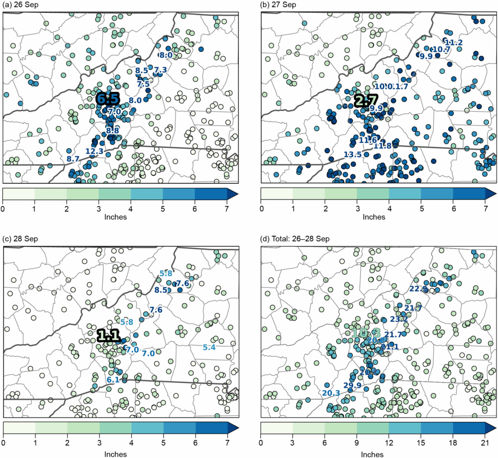
The rain continued until the remnants of the hurricane itself passed right over Asheville two days later. Some of the rivers broke records that had been set by a historic flood back in 1916. The storm claimed 105 lives in North Carolina alone—mostly from flooding and landslides. It took almost two months for the city of Asheville to restore potable water to its residents. The rain also loosened the roots of many trees. When the storm’s winds came through, these trees were uprooted and caused widespread power and cellular outages. At my house, we were without power for about a week, and it took two weeks to get internet and cell service back.
Image: CoCoRaHS daily observations for 26–28 Sep 2024, and the three-day storm total (inches) for Hurricane Helene. Precipitation totals for Dr. Schreck’s station, NC-BC-161, are highlighted by the large bolded number in each panel. (Fig. SB4.1 from “The Tropics” chapter of The State of the Climate in 2024; see report for full caption and explanation.)
What are your concerns in the year ahead?
The Atlantic isn’t as warm as the last couple years, but it’s still much warmer than normal. The Pacific is still in between ENSO-neutral and La Niña. I’m worried that this combination will lead to another active hurricane season and that other communities will experience what we lived through with Helene.
View other posts about the State of the Climate in 2024.
Image at top: Photo taken on September 29, 2024, two days after Hurricane Helene; the image shows the receding Swannanoa River along Highway 70 in Asheville, North Carolina. Credit: Deborah J. Misch, former Graphics team member for the BAMS State of the Climate.