In the dark early morning of July 4, 2025, waters in Texas’s Upper Guadalupe River watershed rose to claim nearly 120 lives. Homes, campgrounds, vehicles, and people were washed away as the Guadalupe rose by up to 30+ feet within hours. The majority of the deaths were in Kerr County, and tragically included 28 people at Camp Mystic, including campers, counselors, and the camp’s director. It was the deadliest flash flood in the United States since 1976.
View footage of the flood wave from the Associated Press.
In the year since, Texas communities and the broader science and policy world have sought to understand the disaster. Two recently released papers in the Bulletin of the American Meteorological Society (BAMS), along with sessions at the AMS 106th Annual Meeting, shed light on what happened in the Texas Hill Country, and how improvements in modeling and prediction might help people be more prepared in the future.
The setup
Catastrophic floods are a fact of life in Central Texas. This area of the Hill Country is known as “Flash Flood Alley” for good reason, as John Nielsen-Gammon (Texas A&M) explained during the Annual Meeting. While July is usually very dry, when moisture moves in from the Gulf of Mexico, the first obstacle it hits is the Hill Country. The moist air is forced upward, condenses, and can drop massive amounts of precipitation. Weak summer winds make for slow-moving storms that rain for long periods over the same area.
The steep terrain and limestone canyons that make the Hill Country so picturesque also make it a flood trap: water runs quickly off exposed bedrock and shallow soils, into narrow channels where river levels rise dangerously fast.
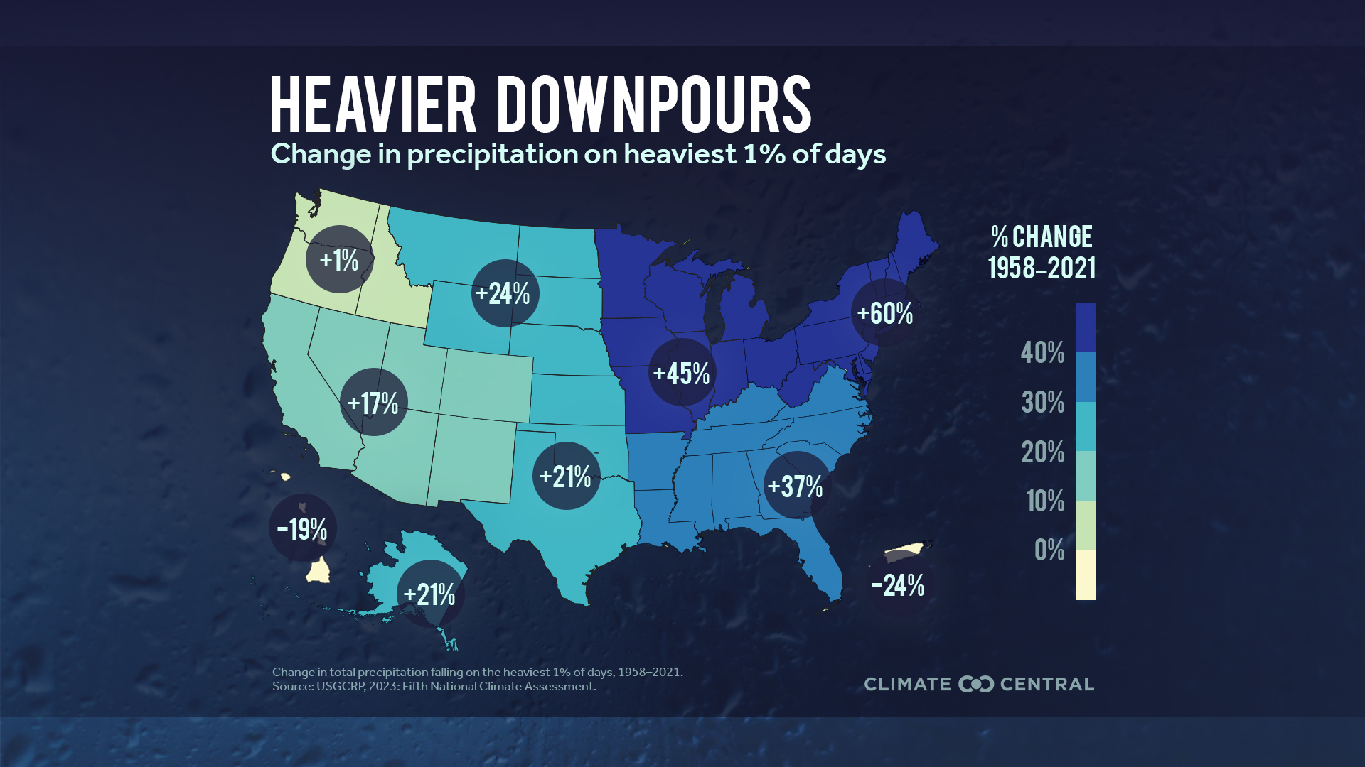
In early July 2025, the usual tropical moisture was charged by remnants of tropical storms in both the Atlantic and Pacific, and a mesoscale convective system (MCS) was making its way across the state, Lance Wood (Harris County Flood Control District) noted during the same Annual Meeting panel session. Soundings taken in Del Rio, Texas, showed that the atmosphere was carrying about as much moisture as it could hold (in the 99th percentile based on climatology and ensemble data). An Annual Meeting presentation by Shel Winkley (Climate Central) suggested that climate change may have added to the moisture in the air. For every one degree Fahrenheit of warming, the atmosphere can hold up to 4% more moisture, and parts of the southern United States, including Texas, have seen a 21% increase in total precipitation falling on the 1% heaviest rainfall days since 1958, according to the Fifth National Climate Assessment.
“This was set up to have extreme rainfall,” said Wood. “The problem is when and where this is going to occur.”
What happened to Camp Mystic?
In the BAMS paper “Hydrometeorological Analysis of the July 2025 Texas Hill Country Flash Flood Disaster,” released online in July 2026, lead author Thomas Galarneau and colleagues find that in addition to the large-scale atmospheric patterns and moisture, local atmospheric dynamics played a major role in the location and magnitude of the disaster, causing a heavy thunderstorm to remain pinned in place over the Guadalupe watershed.
The smaller-scale MCS circulation pattern that moved into the Hill Country on July 3-4, 2025 fed off “an unusually deep plume of tropical moisture,” the authors write. “This circulation increased lift and wind shear in the environment enough to help organize the thunderstorm upstream of Camp Mystic into a rotating supercell,” says Galarneau in a recent AMS press release. “The combination of [local] supercell dynamics and a tropical, moisture-rich environment was critical to producing the extreme rain rates and resulting flood waves. The storm generated more than 10 inches of rain in roughly three hours.”
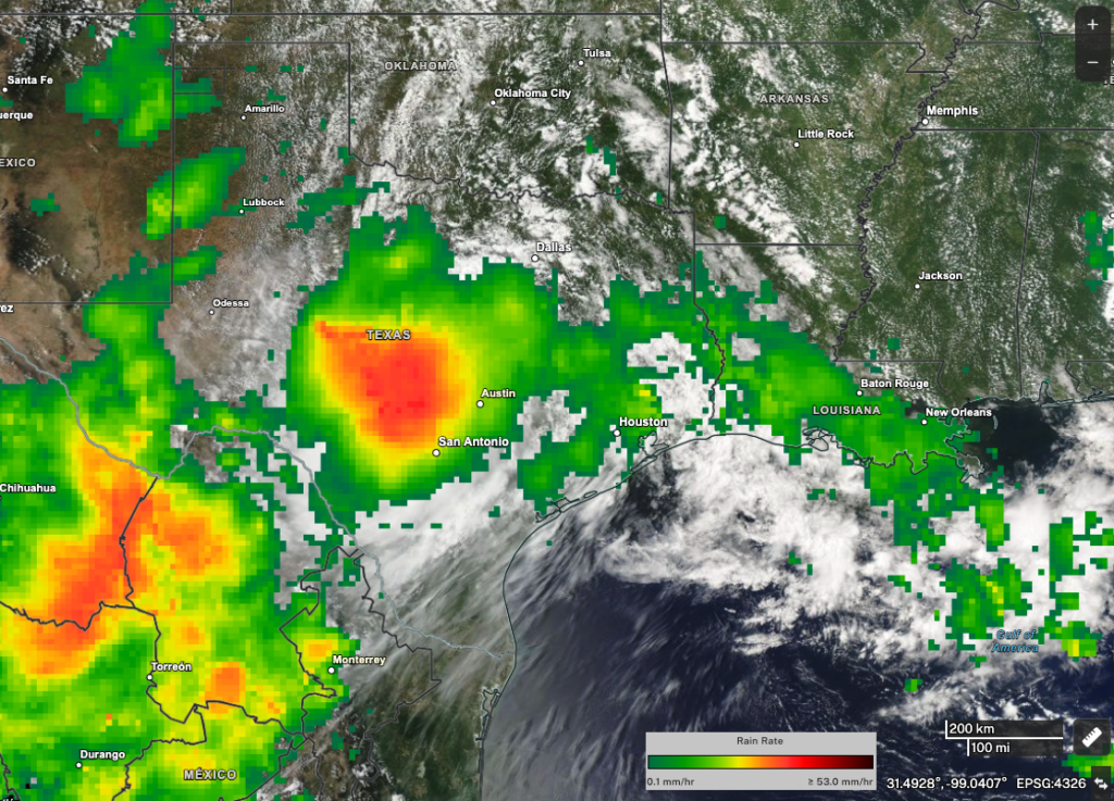
Data from NASA’s IMERG multi-satellite precipitation product show heavy one-day rainfall totals over central Texas on July 4, 2025. [Image credit: NASA Worldview, Jacob Reed (NASA GSFC), view original article here]
Camp Mystic, far upstream, experienced the worst flooding early in the morning—and it sat at the confluence of two rivers. Crucially, says Galarneau, “because [the storm] remained over the same watershed for several hours, flood waves from the South Fork of the Guadalupe River and Cypress Creek reached Camp Mystic at nearly the same time, greatly worsening the inundation.”
Galarneau adds: “This research highlights the importance of closely monitoring situations in which local surface boundaries and smaller-scale atmospheric circulations strengthen winds within a tropical, moisture-rich environment. Even when the broader environment wind shear appears only marginal, these local changes can support dangerous, slow-moving supercells capable of extreme rainfall. It is also important to recognize that small shifts in storm location can determine which watershed receives the heaviest rain and whether multiple flood waves converge on a vulnerable community, as occurred at Camp Mystic.”
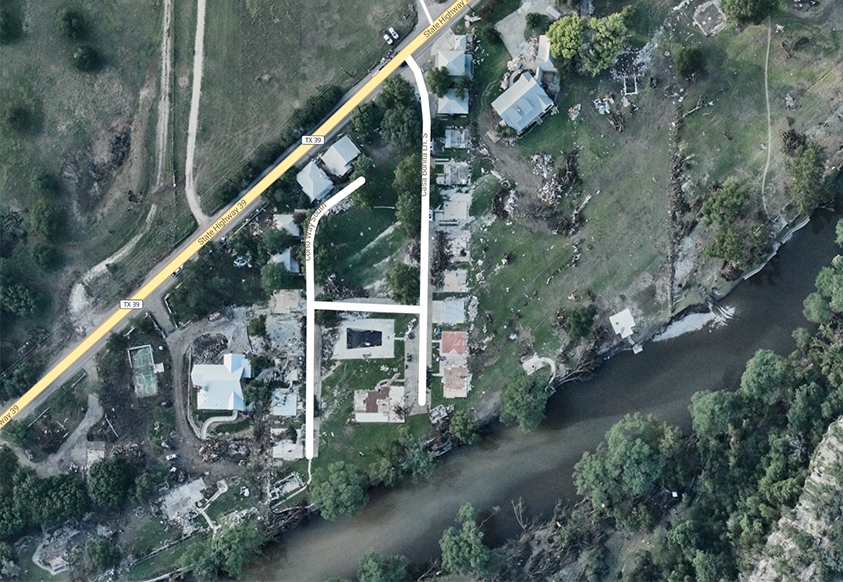
Lance Wood presented the results of a post-event river survey at the Annual Meeting, highlighting the dramatic effects of all this rain in the narrow canyons of the Hill Country. The river gauge for the town of Hunt, Texas, (a few miles from Camp Mystic) was carried downriver. High water marks near the original gauge site revealed an unprecedented river height of 37.52 feet. At Kerrville, near where the north and south forks of the Guadalupe come together, the gauge rose from 2 feet to 34 feet in an hour and a half.

Wood and colleagues would find lines of flood debris at the top of the cabins at Camp Mystic. “The water probably piled up there rather quickly,” he said.
Improving prediction
The precise location of heavy rainfall makes a major difference in areas like the Hill Country, where many different river basins are close together. National Weather Service models in operational use in July 2025 were able to highlight the potential for flash flooding, but researchers hope that ongoing advances in forecasting could someday help predict precipitation intensity and location far in advance for vulnerable places like the Hill Country.
Incorporating higher-resolution data may help account for the local atmospheric factors that determine when and where flash floods take place. To find out whether models still in development might have been able to provide a more precise and usable forecast, Jonathan Gourley and colleagues at NOAA, the National Severe Storms Laboratory, and the University of Oklahoma ran an experimental, fine-resolution configuration of the NOAA/National Severe Storms Laboratory’s “Warn on Forecast” system (WoFS), with model runs fed into the “FLASH” flood prediction system. They fed in data from the lead-up to 2025’s flood disaster.
As the authors note in their BAMS paper “WoFS-FLASH coupled forecasts for the July 2025 Texas Hill Country Flash Flood Disaster,” more than 50% of the model runs “would have yielded forecasts of extreme and record-breaking flows 5–7 [hours] in advance”—accuracy which, in an operational model, would have provided much greater lead time for places like Camp Mystic. This, the authors say, “provid[es] strong motivation to develop a coupled WoFS-FLASH for real-time application,” which might help save lives in the future.
“The scientific community has recognized the need for forecasting improvements of extreme rainfall events,” says Gourley. “The system we evaluated shows the potential to improve information availability and accuracy in the watch-to-warning gap. With better information, users like National Weather Service forecasters and emergency managers will be able to anticipate the specific locations of impending flash flood threats with more lead time so they can respond and communicate more effectively.”
Gourley adds that “NOAA is leading an effort called the Precipitation Prediction Grand Challenge, and a component of this project is improving flash flood prediction. Our model, WoFS-FLASH, will be advanced for eventual operational implementation. The project is just beginning, and our partners at CIWRO [Cooperative Institute for Severe and High-Impact Weather Research and Operations] are already advertising new positions to join the team.”
Human factors
A disaster isn’t just about natural forces. At the Annual Meeting’s first and second “Kerr County, TX Flooding Discussion” sessions, speakers noted that the floods happened over a holiday, in a rural area full of tourists and campers who may not have been aware of the dangers. Decisions and preparedness on the part of trailer park operators, camp counselors, and individuals all might have made a crucial difference.
David Novak, who moderated the first panel, called the floods “a complex human tragedy … It was at night, it was on a holiday when people are disconnecting … and for any one location it was a low-probability but high-impact event.” He also highlighted that there were “numerous heroes in the story, with many, many lives saved with timely warnings and emergency response.”
With any luck, advanced flood prediction will make a difference for more people. However, the decision about when to issue a catastrophic flood warning for a specific area remains delicate. It requires high confidence to avoid turning people off with too many false alarms. As John Nielsen-Gammon pointed out, once forecasters reach that high level of confidence, those far upstream may not have much time to evacuate. More flood gauges upstream, designating people responsible for warnings and evacuation, and better cell phone coverage all might help improve disaster response.
As Shel Winkley noted, broadcast meteorologists also have an important role to play in educating their audiences well before a disaster, helping them understand the risks and how to respond.
Panelists also highlighted how integrated warning teams, with meteorologists, emergency managers, and others, can help reach individuals and decision-makers at all levels in a fragmented environment (and played a key role in saving lives during the 2025 floods).
Low-tech solutions could also help, from informational signs, warning flags, and flood-lines painted on buildings, to simple conversations between tourists and locals.
Brenda Philips, of the University of Massachusetts Amherst, discussed how communities along the Guadalupe River experienced and responded to the flooding differently, focusing on the downstream town of Comfort, Texas. Floodwaters reached Comfort later in the morning, in daylight, after officials had information about the devastation upstream. Local officials activated the community’s sirens and issued evacuation messages, and residents in threatened areas moved to safety. No local residents were killed. Comfort benefited from a combination of downstream lead time, visible conditions, river warning infrastructure, and a community prepared to respond.
Catastrophic floods are by nature high-uncertainty events, Philips said. “Because the exact timing, location, and severity of a catastrophic flood can remain uncertain, preparedness has to happen well before the event. The opportunity to act can close very quickly, and local responders, organizations, and the public have to be primed to act.”