The American Meteorological Society continuously publishes research on climate, weather, and water in its 12 journals. Many of these articles are available via early online access–they have been peer-reviewed, but are not yet in their final published form. Below are some examples of recently accepted research. Note: Some articles may require a subscription for full access.
Journal Articles
What follows are summaries that have not been peer-reviewed or vetted by the article authors; read the full article for peer-reviewed conclusions. Please note that no single study is ever definitive, and each must be taken in the context of the broader scientific literature.
The Greenfield, Iowa, Tornado (2024): Wind-Damage Relationships, Novel LDR Dual-Polarization Analysis, and Integrated DOW/Video Analysis of Turbine Destruction
Bulletin of the American Meteorological Society
Truck-based radar measures among the highest tornado wind speeds on record. Doppler-on-Wheels (DOW) radar teams obtained close-up, high-resolution data on the destructive and deadly 2024 Greenfield, Iowa, tornado. They measured wind gusts over 300 mph, among the highest on record. Their data allowed the first-ever high-res mapping of tornado wind speeds with structural damage (DOW-measured wind speeds were 21% higher than estimates based on damage surveys alone), found a signature for identifying large flying debris that may distinguish intense tornadoes, and (combined with storm-chaser videos) allowed precise analysis of the destruction of wind turbines outside Greenfield. Read more about this on AMS Headlines.
Potential Depictions of Noctilucent Clouds in William Ascroft’s Sketches in 1884
Bulletin of the American Meteorological Society
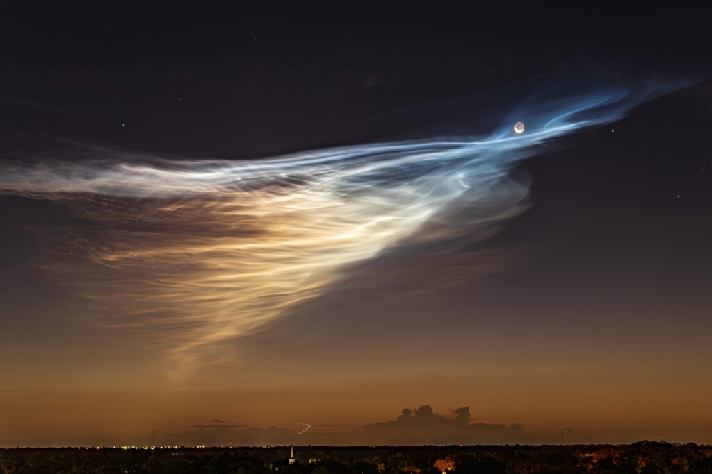
Krakatoa’s noctilucent clouds may have happened (and inspired art) earlier than assumed. The first known depictions of noctilucent clouds (NLCs) are said to have occurred in 1885, after Krakatoa’s 1883 eruption injected water vapor high in the atmosphere. Based on the angle of the clouds and sun, this paper proposes that 1884 twilight sketches by British artist William Ascroft (view example) also show NLCs. The authors model vapor transport to show that it was possible for the H20 from Krakatoa to have reached the correct location and height as early as a year after eruption.
Advancing Prediction of Flooding, Morphological Change, and Damage from Hurricanes: The NOPP Hurricane Coastal Impacts Initiative
Bulletin of the American Meteorological Society
Predicting coastal hurricane destruction. The National Oceanographic Partnership Program’s Hurricane Coastal Impacts project, a high-intensity, multi-institution observation and modeling project, assessed whether it was feasible to predict infrastructure impacts from hurricanes. The effort yielded high-density observation datasets from offshore to onshore, accurate local flood depth predictions, and estimates of building damage from storms, providing valuable building blocks for future forecasting. Project data and models proved capable of predicting the catastrophic breaching of Florida’s Sanibel Causeway islands during Hurricane Ian two days in advance of landfall.
Built From Pressure
Bulletin of the American Meteorological Society
Denying weather data to the Nazis played a key role in WWII. A gap in German weather forecasting for D-Day gave the Allies a major advantage as they launched the Normandy Invasion in the interval between two storms. This essay outlines the systematic Allied efforts to deny Germany direct ground-level weather observations upwind of the English Channel—efforts which resulted in their D-Day forecasting advantage—along with the postwar data-sharing efforts that followed, and upon which modern forecasting still relies.
Energy-Enstrophy Balance and the Evolving Shape of Jupiter’s Great Red Spot
Journal of the Atmospheric Sciences
Jupiter’s Red Spot may stay smaller for some time. Over recent decades, Jupiter’s Great Red Spot (GRS) has become smaller and more circular, yet shows no signs of dying out. The authors’ analysis suggests that a circular vortex is the most energy-efficient shape for a prescribed area, and is able to withstand small disturbances. This suggests that the current shape of the GRS could last for a long time, yet it may not be permanent, as other dynamic processes could still interfere.
Cumulative Oceanic Response to Sequential Tropical Cyclones in the Northern South China Sea
Monthly Weather Review
Tropical cyclones weaken their successors. Analysis of satellite observations and existing datasets reveals that tropical cyclones (TCs) in the South China Sea cause a distinct evolution in oceanic and atmospheric conditions that weakens subsequent TCs in the same area. This information has implications for improving intensity prediction in areas where TCs form in rapid succession.
The Role of Age in Flood Mortality: A Study of Patterns in Europe and the Mediterranean Region
Weather, Climate, and Society
Older adults are overrepresented in European/Mediterranean flood deaths. Examination of a Euro-Mediterranean database of flood mortality between 1980 and 2020 finds a “significant and growing” overrepresentation of senior adults (age 65+). In contrast to younger people, who are more likely to be killed by floods while in transit outdoors, older flood victims were more likely to die while immobile indoors, suggesting a need for age-sensitive disaster preparedness strategies.
Climate Change or Mismanagement? Partisan Attribution and Public Support for Urban Wildfire Policy
Weather, Climate, and Society
Republicans and Democrats assign different causes to urban wildfires. Urban wildfires are becoming more destructive. This study finds that Democrats are likely to attribute this increase primarily to climate change (and to support climate mitigation policies), while Republicans are more likely to emphasize poor government management of forests (and support fire-management policies). Californians, more exposed to urban wildfires, were more likely to have a multifaceted understanding of the causes. Communications emphasizing the multicausal nature of urban wildfires may reduce polarization and build broader support for integrated wildfire governance strategies.
The Global Kilometric Tropical Cyclone Wind Database (CyclObs) Enabling High-Resolution Data-Driven Studies
Bulletin of the American Meteorological Society
Global database will enhance understanding of hurricane damage potential. Accurate, high-resolution ocean wind data are essential for improving tropical cyclone (TC) forecasts and research. CyclObs is a global, kilometer-scale database of tropical cyclone TC ocean surface winds derived from satellite observations, with data from at least 500 tropical cyclones from 2013 to the present, quality controlled by other observations. The database, created by international partners, holds the potential for better understanding of TC dynamics and the ability to enhance forecasting.
Neighbor-Regression Quality Control Algorithms for Detecting Blocked Rain Gauges
Artificial Intelligence for the Earth Systems
African rain monitors need additional safeguards. Reliable rainfall measurement is key for agriculture, drought monitoring, flood forecasting, and climate adaptation. This study finds that leading methods for detecting blocked rain gauges (using data from neighboring gauges) perform well in Oklahoma but become much less reliable across much of sub-Saharan Africa because tropical rainfall is highly localized and neighboring stations often do not receive the same rain. As Africa expands its weather-observation infrastructure, weather services may need additional safeguards, such as denser station networks, paired gauges, and satellite rainfall data.
Smokelyze.org: Advanced Spatiotemporal Analytics for Wildfire Smoke and Air Quality
Bulletin of the American Meteorological Society
New app helps quantify air pollution from smoke and assess health impacts. Due to fragmented data and lack of tools, assessing air pollution from wildfire smoke is a difficult endeavor for regulators and health researchers. Smokelyze, a free, web-based app, integrates peer-reviewed data from many sources to quantify the contributions of wildfire smoke to particulate and ozone pollution at stations across the United States.
Observed Warming and Moistening Trend over South Asia in Recent Decades Consistent with CMIP6 Multi-model Simulations
Journal of Climate
South Asia moistening trend is consistent with global warming. Climate change is causing increased dryness over global land areas, yet South Asia has experienced more humid heating instead. Multiple datasets demonstrate this consistent response, and this study shows it to be consistent with climate change projections. The authors suggest that this trend may be due to increased convergence of moist air during the monsoon.
Air Pollution Amplifies the Humid Heat Anomalies in India
Bulletin of the American Meteorological Society
Air pollution increases humid heat danger. Under climate change, humid heat events are projected to increase in India—especially in the densely populated Ganges Plain, which also experiences severe air pollution. While air pollution can reduce surface heat, especially in dry weather, this study finds that pollution exacerbates about 20% of humid heat events by inducing a heat dome effect, presenting a serious health risk for the future.
Weather Regime Drivers of Power Outages over the Continental U.S.
Journal of Applied Meteorology and Climatology
Mapping U.S. power outages to atmospheric patterns. The relationship of power outages to large-scale weather patterns is poorly understood due to limited national data. A new approach for identifying power outages of all sizes shows that outage risk is linked to specific atmospheric circulation patterns. Outage risks increase in different regions of the United States depending on the daily weather regime (for example, when there is unusually high pressure near Greenland, outages increase in the southern United States); this knowledge may help transmission operators better plan for possible impacts.
Extremes, Teleconnections, and Trends in Growing Season Precipitation over the Corn Belt, 1182–2023 CE
Journal of Climate
700+ years of rain and drought in the Corn Belt. Tree-ring reconstructions suggest that the twenty-first century saw the wettest decade in 700 years in the North American Corn Belt, possibly enhanced by increased irrigation. Meanwhile, 1627-39 was the most severe, sustained, and unbroken drought in the reconstruction for at least 600 years, with no analog in recent centuries. This period saw simultaneous drought in China, North America, and Eastern Europe.
Using Behavioral Economics to Examine Community Shelter Use Intention in a Kansas Sample
Weather, Climate, and Society
Time to reach community shelters impacts Kansans’ tornado sheltering decisions. A survey of 1,859 Kansas residents asked whether they would wait, shelter at home, or travel to a community shelter during a tornado. Travel time to reach the community shelter affected the decision to leave for such a shelter, regardless of other factors. Residents of multifamily and manufactured homes were more likely to use community shelters, whereas those with a basement were more likely to shelter at home. Middle-income households were most likely to leave for a community shelter.
You can view all research published in AMS Journals at journals.ametsoc.org.
About AMS Journals
The American Meteorological Society continuously publishes research on climate, weather, and water in its 12 journals. Some AMS journals are open access. Media login credentials are available for subscription journals. Journals include the Bulletin of the American Meteorological Society, Weather, Climate, and Society, the Journal of Climate, and Monthly Weather Review.