Overview
We distill the essence of a pioneering effort to decode one of Earth’s most dynamic precipitation systems, offering tools and insights to tackle mountain weather challenges worldwide.
Who
A multidisciplinary team of scientists, led by Xuelong Chen and Yaoming Ma, conducted this groundbreaking research under the Second Tibetan Plateau Scientific Expedition and Research Program (STEP). The team included experts from the Chinese Academy of Sciences, China Academy of Meteorological Sciences, and international collaborators from Sweden and other institutions.
What
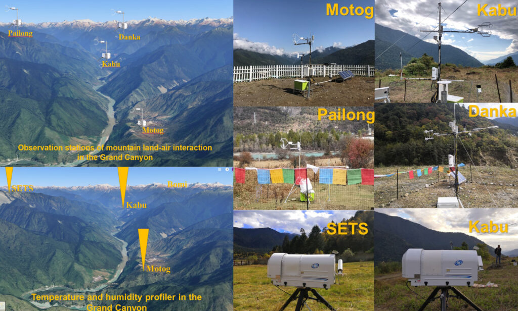
Our study presents the first comprehensive observation system designed to investigate precipitation processes in the Yarlung Zsangbo Grand Canyon (YGC), a critical water vapor channel linking southern Asia to the Tibetan Plateau (TP). The system integrates advanced instrumentation—such as cloud radars, microwave radiometers, GPS water vapor sensors, eddy covariance systems, and disdrometers—to capture the interplay between water vapor transport, cloud dynamics, and precipitation microphysics in this complex mountainous region.
When and Where
The observation network was established in 2018 and fully operational by 2021, spanning the YGC’s southern entrance to its northern reaches. Key sites like Motog, Kabu, and SETS (Southeast Tibet Station) were strategically placed to monitor gradients in water vapor, atmospheric conditions, and precipitation across varying elevations (511–3,330 m).
Why
The YGC is a hotspot for extreme rainfall and convective activity, driving glaciers, rivers, and frequent geohazards like landslides. Yet, its remoteness and rugged terrain have left it historically underobserved, limiting weather prediction and climate modeling accuracy. Our work addresses critical gaps by:
Linking Water Vapor to Extreme Rainfall: The study reveals how humid air from the Himalayas ascends through the canyon, fueling intense precipitation events on the southeastern TP.
Improving Microphysical Understanding: Unique raindrop spectra and cloud vertical structure data challenge assumptions about precipitation processes in high-altitude regions.
Supporting Disaster Resilience: Findings aid in predicting floods and landslides, crucial for safeguarding infrastructure like the Sichuan–Tibet railway.
How
The team deployed an innovative network of 19 sites with cutting-edge tools:
Cloud Radars: Captured vertical cloud structures, distinguishing convective and stratiform precipitation.
Microwave Radiometers (MWR): Tracked real-time water vapor and temperature profiles, validated by 264 radiosondes.
Disdrometers and Micro Rain Radars (MRR): Quantified raindrop size distributions and growth processes, revealing distinct spectra compared to lowland areas.
Eddy Covariance Systems: Measured land-atmosphere energy exchanges to understand local circulation’s role in moisture transport.
Key Findings
Microphysical Surprises: Raindrop spectra peaked at 0.35 mm, smaller than lowland observations, with convective drops larger (5.75 mm max) than stratiform (5.25 mm). Falling speeds were higher, suggesting unique particle interactions.
Water Vapor’s Critical Role: Abnormally high water vapor precedes extreme rainfall by 1–4 days, with the YGC acting as a conveyor belt for moisture. MWR data showed the total column water vapor (TCWV) before extreme rainfall peaked at three times the baseline level observed under dry conditions.
Model Improvements: The data exposed biases in ERA5 reanalysis and IMERG satellite products, which misrepresent diurnal precipitation cycles and underestimate high-altitude rainfall.
Impact
This work transforms our ability to study mountain meteorology by:
Providing the first high-resolution dataset for the YGC, now shared via the National Tibetan Plateau Data Center.
Informing parameterizations in weather and climate models, particularly for extreme events.
Offering a blueprint for monitoring complex terrains globally, from the Andes to the Alps.
Looking Ahead
Future research will leverage this network to unravel the “seeder-feeder” cloud mechanisms driving nocturnal rainfall and refine disaster early-warning systems. By bridging observation and modeling, the project underscores the TP’s role as Asia’s “Water Tower” and its vulnerability to climate change.
Read the Full Article
Explore the detailed methodology, preliminary results, and data access in BAMS.
Check out a conversation with Xuelong Chen.