Key messages from "Winter Lightning to the Lee of Lake Ontario: The Lake-Effect Electrification (LEE) Field Campaign," by Scott M. Steiger (State University of New York at Oswego), Eric C. Bruning, Vanna C. Chmielewski, Geoffrey Stano, John Trostel, Kristin M. Calhoun, Kaitlyn R. Jesmonth, Bee Lamsma, Timothy Lang, Shaun Laurinaitis, Jessica Losego, Jacquelyn S. Ringhausen, Michael Stock, Yonggang Wang, Sean M. Waugh, Stephanie A. Weiss, Thomas Weist, and Thomas White. Published online in BAMS, November 2024. For the full, citable article, see https://doi.org/10.1175/BAMS-D-23-0176.1.
It was during a summer of 2014 meeting with a group of undergraduate student researchers at SUNY Oswego, while analyzing the lightning data collected during the 2013–14 Ontario Winter Lake-effect Systems (OWLeS) National Science Foundation (NSF) project, that Oswego Professor Robert Ballentine pointed out: “Hmmm . . . the lightning looks like it occurred over the newly built wind turbines east of Lake Ontario during the field campaign.” This “Aha” moment, along with Eric Bruning (Texas Tech University) approaching lead author Scott Steiger at an AMS conference about an idea to study lake-effect thunderstorms many years prior, sparked the impetus behind the NSF grant that would eventually become the Lake-Effect Electrification (LEE) project to the lee of Lake Ontario in upstate New York.
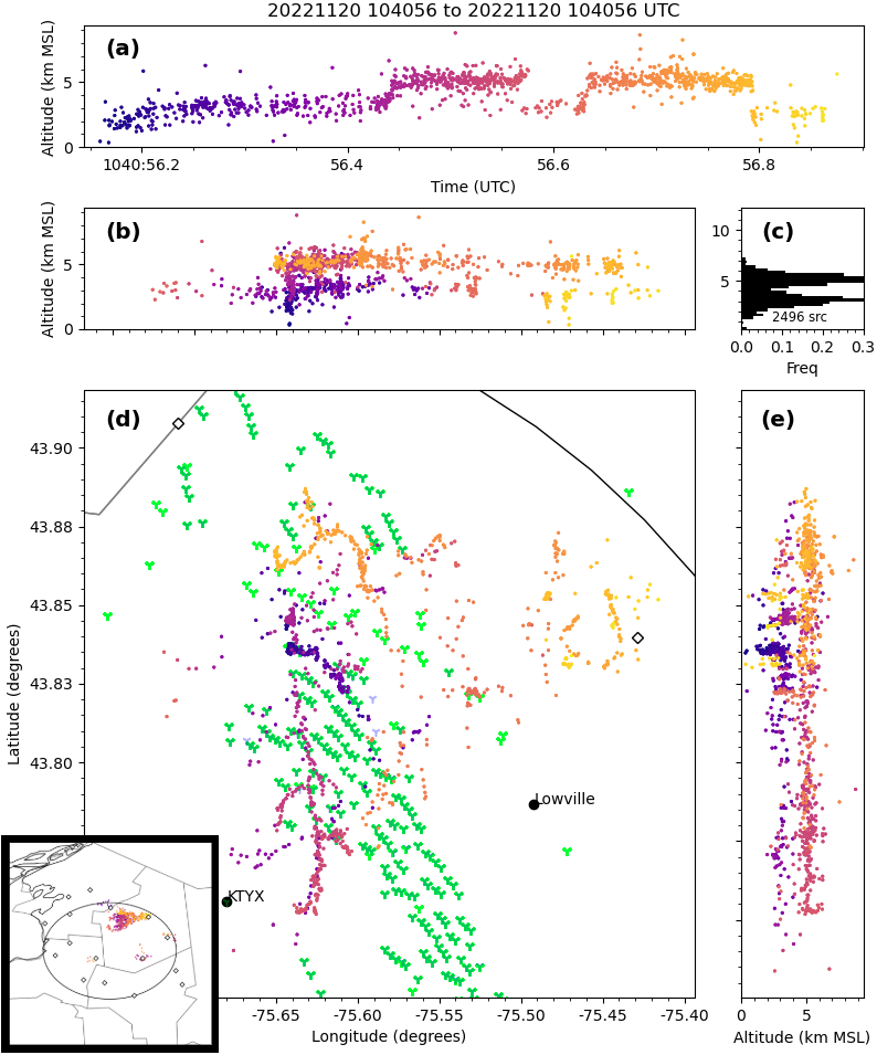
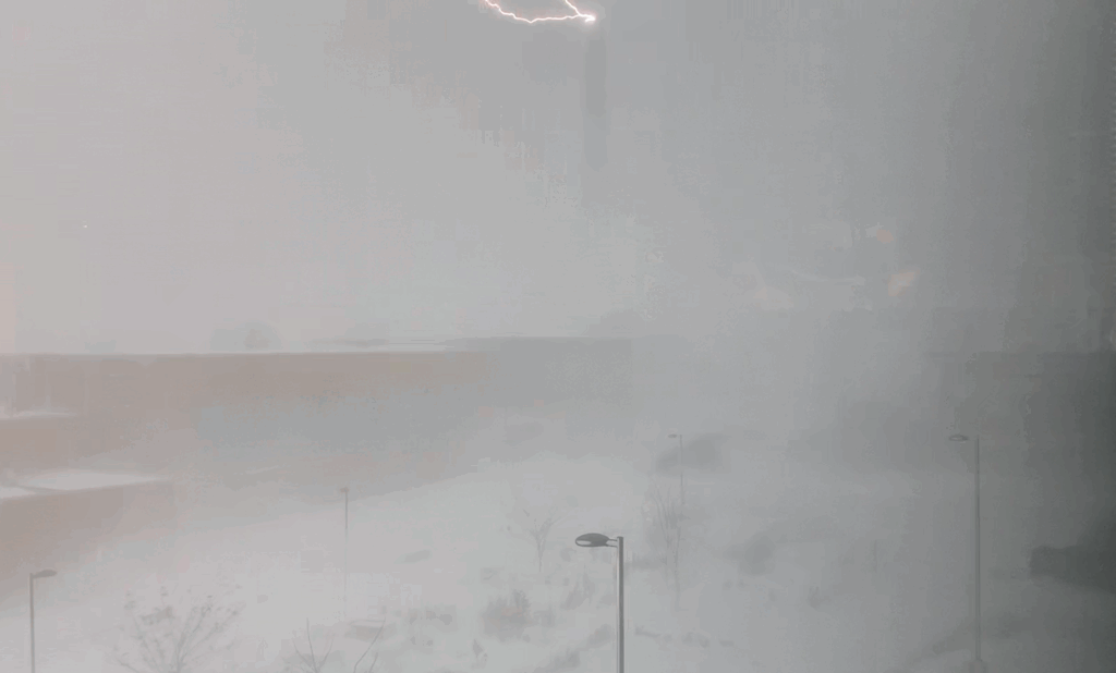
Project LEE was a first of its kind in studying the electrification and lightning of lake-effect storms. For the first time, we plotted [with lightning mapping array (LMA) observations, which map out a flash with 10 to more than 100 points] how individual lightning flashes traveled through the convective and stratiform precipitation regions of the lake-effect storm and were able to determine the locations and strengths of electrical charge regions. For example, we discovered the presence of a substantial positive charge region at low levels near the Lake Ontario shoreline in one of our case studies. More than one-third of the 246 identified winter lake-effect lightning flashes were associated with man-made tall objects, including wind turbines. Another interesting result was that some lightning traveled along one height while other flashes jumped between two levels. Lastly, one of the most fascinating observations was the mapping of a lightning channel that was also video-recorded striking a power stack in Oswego.
More than 20 SUNY Oswego undergraduate students were involved in collecting field data during the September 2022–March 2023 period. It took a team (7–8) of these students and some of the scientists in launching each electric field sonde into the storm in harsh wintry conditions [heavy, blowing snow; wind gusts to more than 50 mph; visibility near 0 miles, and deep snowpack (multiple feet)]! The balloon carrying each instrument package was the size of a small car. The students were busy making sure the LMA units were clear of snow after each storm and helping scan the storm with the Doppler on Wheels mobile radar. It was a great experience for so many undergraduates, who later told Steiger that the experience inspired them to study harder and apply to graduate school.
Project LEE’s results are not just applicable to the understanding of lake-effect storm electrification, but can also be used to improve hypotheses on storm electrification in general. The basic ingredients of convective updrafts mixing graupel, ice crystals, and supercooled water for electrifying clouds to the point of lightning initiation are present in lake-effect clouds. In addition, these storms are “easier” to sample than typical warm-season deep saturated convection, as lake-effect clouds are shallower and persistent over the same region for several hours, with the mixed-phase portion of the clouds much closer to the ground. Lake-effect storms also present a way to test the threshold for lightning initiation, as many storms do not produce lightning.
We are currently planning a LEE, Part 2. One of our key instruments, the particle size, image, and velocity (PASIV) probe, did not operate well in the wintry conditions—keep in mind this was the first time for many of these instruments to be used in winter, as they are typically used to observe summer storms. Also, many of our sonde balloons popped before launch, as the cold air made the launch tube (a pool cover–like object in which the balloon was inflated) brittle, and it would scrape and damage its balloon. Some balloons also popped right before launch when wind-blown, large (0.75-in. diameter) graupel would strike them. This caused us to not meet some of our major objectives, such as measuring the electric field sounding near shore and over a nearby wind turbine field simultaneously. Nevertheless, much great, first-of-its-kind data were collected during the LEE project that hopefully will propel a follow-up grant in the coming years to collect the particle imagery and electric field data necessary to obtain a fuller picture of storm electrification!
METADATA
BAMS: What would you like readers to learn from this article?
Scott Steiger (State University of New York at Oswego): Many people are struck with awe when they witness the power of lightning, but there is something even more special to witness a flash during a snowstorm (for example, Jim Cantore from The Weather Channel has been recorded “geeking out” several times during thundersnow!). It is something of interest to many people, not just meteorologists, as to why a summertime event occurs when it is not expected during a blizzard. For the meteorologist, we want them to learn under what conditions to expect lake-effect lightning to protect the public, while for wind turbine operators this article might help them mitigate the effects of the lightning (for example, turbines are less likely to initiate lightning when not rotating).
BAMS: How did you become interested in the topic of this article?
SS: This research was driven by pure science: How do wintertime clouds, usually not known for producing lightning, become electrified? What are the similarities and differences between warm- and cold-season thunderstorms? I personally gained interest as I have witnessed thundersnow several times a winter living in Oswego, New York, downwind of Lake Ontario—a region I believe experiences this event the most in the world (maybe behind Japan, where sea-effect thunderstorms develop) due to its meteorology and terrain.
BAMS: What got you initially interested in meteorology or the related field you are in?
SS: I’ve had a long history with lake-effect snow. There were many times as a child growing up west of Rochester, New York, when the elementary school I attended 10 miles from my home would experience heavy lake-effect snow, and by the time I got home it was sunny with no snow on the ground—so frustrating to someone who wanted the snowstorm where they lived! Since then, I have loved experiencing lake-effect snow (it never gets old), and I still get mad when my home gets missed by the snowband (just ask my wife and kids—it’s a strange obsession!)!
BAMS: What surprised you the most about the work you document in this article?
SS: The biggest discovery to me was the observations of lightning channel development in these storms. This was the first time to my knowledge that anyone has ever mapped out individual lightning flashes in lake-effect storms; so to be able to see how the lightning channel spreads along a lake-effect precipitation band and jumps quickly to different altitudes was awesome! Also, I believe this was the first time that the vertical profile of the electric field in these storms was measured. Cool discovery stuff!
BAMS: What was the biggest challenge you encountered while doing this work?
SS: The biggest challenge was launching the electric field sondes into the storms. First of all, trying to target a lake-effect snow band’s core that can be a couple of miles wide while swinging south was really hard (we failed on this a few times)! But there were issues related to extreme cold and wind: we had a “Superbowl” of an event on November 20, 2022 when there were so many flashes, many hitting the turbines every few minutes for an hour, but no electric field sondes were launched that day because the wind-blown large graupel pellets kept popping the balloons!
BAMS: What’s next? How will you follow up?
SS: We have several manuscripts in the pipeline, including a detailed case study of the aforementioned “Superbowl” event and a manuscript describing detailed lightning characteristics from each event, including those flashes that initiated from man-made objects like wind turbines.