Key messages from "Tracking Atmospheric Motions for Obtaining Wind Estimates Using Satellite Observations—From 2D to 3D," by Jun Li [China Meteorological Administration], David Santek, Zhenglong Li, Agnes Lim, Di Di, Min Min, Christopher Velden, and W. Paul Menze. Published online in BAMS, February 2025. For the full, citable article, click on the linked title above.
Two-dimensional (2D) tropospheric winds are currently provided via active and passive remote sensing from meteorological satellites and are routinely assimilated into numerical weather prediction (NWP) models. Three-dimensional (3D) wind measurements (vertical profiles) with expansive geographical coverage and high temporal resolution are crucial for understanding atmospheric dynamics, improving weather forecasts, and enhancing climate models. 3D wind measurements with better coverage and accuracy will soon be possible from geostationary satellite hyperspectral infrared (IR) sounders (GeoHIS) as well as combinations of active and passive observations. Understanding the status, advantages, limitations, and future directions of these anticipated approaches is important to the international planning of future satellite imaging/sounding instruments and applications. With our research, we provide an overview of the progress toward tracking atmospheric features measured by weather satellites for obtaining tropospheric winds and the evolution from 2D to 3D coverage; we also summarize potential applications, associated challenges, and future perspectives. We find, overall, that traditional atmospheric motion vector retrieval methods have proven valuable to global data assimilation, but have limitations in precise height assignment and a general inability to capture vertical wind structure.
Although satellite active remote sensing methods hold the promise of providing accurate wind profiles, their current spatial coverage is very limited, and consequently so is the impact on the resulting global analyses. Hyperspectral IR sounders, especially GeoHIS, offer a complementary approach for 3D wind observations. Although 3D wind retrievals have been attempted using hyperspectral IR sounders flying in polar orbit, relatively large uncertainty and limited error characterization have restricted their applications in data assimilation in NWP. The uncertainties result from retrieval errors, coarse spatial resolution, parallax effects, and limited temporal and spatial sampling. GeoHIS can overcome some of these limitations and provide improved 3D wind observations. Specifically, we propose 3D wind retrievals from both a physical method and an artificial intelligence (AI) method.
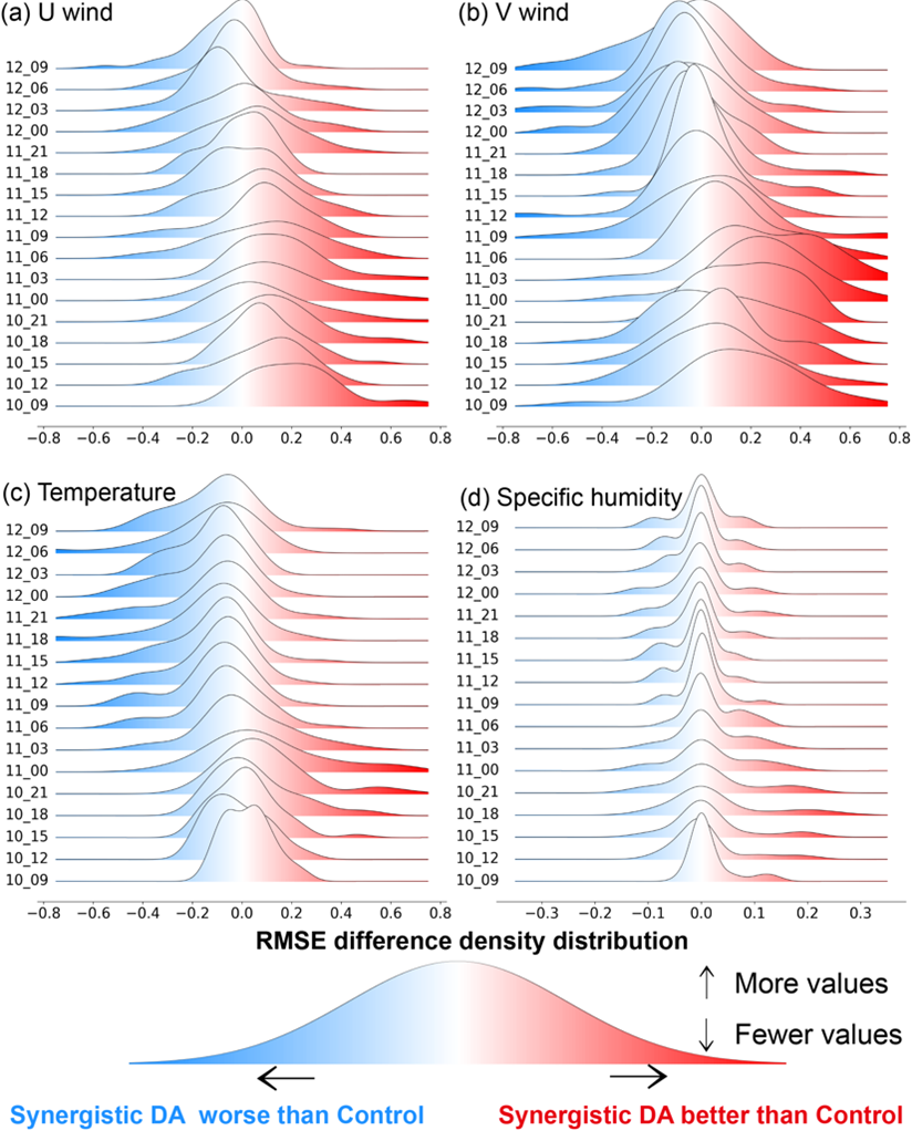
Ridgeline plot for (a) U wind (in m s–1), (b) V wind (m s–1), (c) temperature (K), and (d) specific humidity (g kg–1). Each curve represents the distribution of the root mean square error (RMSE) differences (control experiment minus GIIRS 3D wind data assimilation experiment) at different forecast times obtained through Kernel Density Estimates (KDE). The color distribution and the position of the curves relative to 0 indicate the trend of RMSE differences over the forecast time; positive anomalies indicate smaller errors in the synergistic assimilation experiment, implying a positive impact, while negative anomalies indicate smaller errors in the control experiment, suggesting a negative impact.
Our research demonstrates the feasibility of 3D wind retrieval from GeoHIS using 15-minute interval GIIRS (Geostationary Interferometric Infrared Sounder) targeted observations. The AI method for 3D wind retrieval combines spectral, temporal, spatial, and geometric information from GIIRS observations. Numerical experiments confirm the added value of assimilating GeoHIS 3D winds into an NWP model for improving tropical cyclone forecasts; we found that both dynamic and thermodynamic information contribute to the improvement, and that combining both types of information provides the best results. Also important is the finding that combining collocated imaging and soundings not only expands 3D winds from clear skies to cloudy skies, but also improves the retrieval accuracy. This suggests that placing a high-resolution imager and a hyperspectral IR sounder on the same platform or nearby platforms will enhance the 3D wind products and applications. The transition from single-level feature tracking to 3D wind profile retrievals represents a significant advancement in the ability to comprehensively characterize atmospheric dynamics. 3D wind measurements will provide a more complete description of the atmospheric state and processes, and thus enable improved accuracy in weather forecast models. The desired 3D winds can be realized through GeoHIS measurements and through the combination of both active and passive observations from future satellites.
METADATA

“I graduated from Peking University with a math degree and then was recommended for study at the Cooperative Institute for Meteorological Satellite Studies (CIMSS) at the University of Wisconsin–Madison, known as the birthplace of satellite meteorology. My mentor, William L. Smith, encouraged me to study the extraction of atmospheric information from satellite measurements. I found this to be a difficult problem. Real-time applications, on one hand, require quick solutions with good accuracy, while numerical methods, on the other hand, require considerable computation time. Thus, near-real-time quantitative applications require great efficiency, otherwise only a portion of the data can be used. This challenge inspired me to solve the problem using mathematical methods and data analysis tools. With higher temporal, spatial, and spectral resolutions, utilization of GeoHIS is even more challenging for developing scientific algorithms and technical approaches.”
—Jun Li, China Meteorological Administration
Jun Li on the banks of the Jinjiang River in China.
A Conversation with the Author
. . . . . . . . . . . . . . .
AMS: What would you like readers to learn from this article?
Jun Li (China Meteorological Administration): 2D tropospheric winds are currently provided via active and passive remote sensing from meteorological satellites and have played an important role in weather forecasts, especially via assimilation into numerical weather prediction models. 3D wind measurements offer a more complete description of the atmospheric state and processes, and thus can improve the accuracy of weather forecasting models. 3D winds are rarely available with current remote sensing measurements, but they could be realized through GeoHIS as well as combined active and passive observations from future satellites. The transition from single-level feature tracking to 3D wind profile retrieval represents a significant advancement in our ability to comprehensively characterize atmospheric dynamics.
AMS: How did you become interested in the topic of this article?
JL: I spent many years extracting atmospheric information from satellite measurements for near-real-time weather forecast applications such as situation awareness. With the large data volume that was to be processed, my focus was on developing algorithms and software with high accuracy and computational efficiency. Atmospheric temperature and moisture profiles are the primary parameters to be extracted for deriving thermodynamic information, atmospheric instability, and water vapor amounts that are highly correlated with storm initiation. Beyond thermodynamic information, dynamic information receives significant attention in weather forecast applications. It is derived from tracking atmospheric motions in features such as water vapor and clouds, but usually at just a single level. Several questions arise: How can we get 3D winds (profiles) from weather satellite measurements? How can we use them for improving forecasts? What is the added value on high-impact weather forecasts if both thermodynamic and dynamic information are assimilated into NWP? These science questions motivated me to study the 3D winds using satellite measurements.
AMS: What surprised you the most about the work you document in your article?
JL: The 3D winds from GIIRS-targeted observations provide added value for predicting high-impact weather events (such as tropical cyclones) when they are assimilated into numerical weather prediction models. Both thermodynamic and dynamic information contribute to the improvement; combining them in the assimilation provides the best positive impact. Those findings prove the importance of the current and upcoming international GeoHIS systems from China, Europe, the United States, Japan, and other countries
AMS: What was the biggest challenge you encountered while doing this work?
JL: Limited data sources pose a big challenge to developing a methodology and demonstrating a validated positive impact. Currently, only a limited number of cases from GIIRS with targeted observations at high temporal resolution are available. When the InfraRed Sounder from Meteosat Third Generation data become available, the GeoHIS data will be available in near–real time, providing an enhanced opportunity for 3D wind study and application.
“Ground-based radar measurements also provide wind information. The next step is to combine satellite passive remote sensing data and ground-based radar measurements. These could provide winds with better quality and hopefully improve the NWP-based forecast. When available, the InfraRed Sounder data will be used to optimize possible methodologies. Another task will be to fuse multisource wind data from satellites, the ground, and NWP for nowcasting applications.”
—Jun Li, China Meteorological Administration

Jun Li at the International Radiation Symposium
held in Hangzhou, China, in June 2024.