by Kun Zhao et al.1
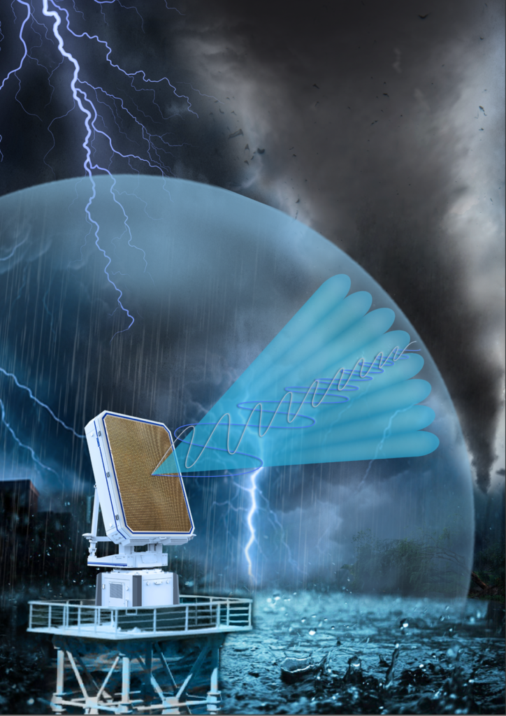
The Greater Bay Area (GBA) of China—home to more than 85 million people—is increasingly vulnerable to severe convective weather due to rapid urbanization, coastal exposure, and complex terrain. Short-lived tornadoes, localized downbursts, and flash floods frequently threaten this densely populated region, which encompasses the major cities of Guangzhou, Hong Kong, Shenzhen, and Macao. Yet conventional S-band weather radars, limited by their coarse spatial resolution and slow volumetric scan rates, often fail to capture these rapidly evolving hazards in this region with sufficient detail. To overcome these limitations, a new operational infrastructure has been established: a dense network of more than 50 X-band, dual-polarization phased array radars (PARs), forming the most advanced and extensive system of its kind worldwide. With rapid volumetric updates (as frequent as every 60 seconds), agile beam steering, and urban-scale deployment, the network delivers real-time, high-resolution observations of atmospheric processes, bridging the gap between hazard detection, prediction, and early warning.
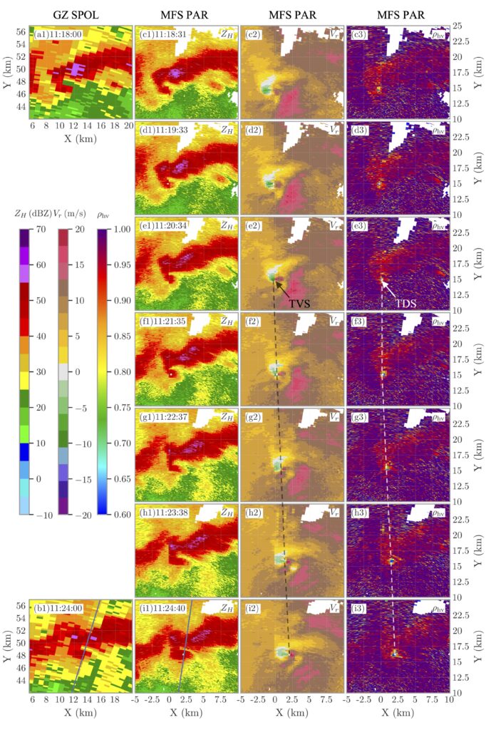
Unlike mechanically rotating radars, which require 5–6 minutes to complete a volume scan, each PAR unit in this network rotates mechanically in the azimuthal direction, while electronically forming beams that scan in the elevation direction, enabling flexible, adaptive scanning strategies that can be dynamically directed toward the most hazardous sectors. While X-band systems have a more limited range than their S-band counterparts, their compact coverage is well-suited to dense urban clusters, providing high-resolution, low-level observations that S-band radars cannot provide. During recent severe weather events, including tornadic storms in the Pearl River Delta, the network captured finescale features such as tornado vortex signatures (TVS) and, for the first time in this region, tornado debris signatures (TDS) lofted above 3 km. These signatures were detected and tracked several minutes earlier than by the national radar system, providing unprecedented detail on the rapid vertical development of tornadic debris clouds. This minute-by-minute evolution opens new avenues for understanding storm dynamics and improving emergency warning lead times.
Beyond hazard detection, the assimilation of data from the network into convective-scale numerical weather prediction (NWP) models has markedly improved the representation of storm structure, rainband evolution, and the timing of high-impact events. Real-time fusion of data from multiple PAR units enables full 3D reconstruction of convective systems across the GBA. Early tests indicate that forecasts initialized with PAR-enhanced observations yield more accurate nowcasts, an essential capability for emergency management in megacities, where even a few minutes more lead time can be lifesaving. Additionally, the system architecture supports AI-driven feature tracking and hazard classification, representing a conceptual shift from traditional, centralized radar operations toward a distributed, intelligent sensing network that not only observes the atmosphere but also interprets it.
Operating such a dense and data-rich network presents significant challenges, particularly in data management and system coordination. The rapid volumetric scans generate large volumes of dual-polarization data, requiring innovative strategies for data reduction, compression, and prioritization to support timely processing and analysis. Maintaining calibration consistency and synchronization across more than 50 radars also demands robust engineering solutions and stringent operational protocols. Despite these complexities, the network offers a scalable model for other urban regions worldwide facing aging radar infrastructure and increasing vulnerability to high-impact weather. Future directions include adaptive scanning strategies, advanced radar–radar compositing, and deeper integration with satellite, lidar, and ground-based sensors, paving the way toward a next-generation urban atmospheric observing system seamlessly linked with intelligent forecasting and decision-support platforms.
A Brief Conversation
with the Author
“Many of us entered the field driven by a curiosity about extreme weather. I was fascinated by severe convective storms and the physics behind precipitation systems. As a student, I spent countless hours analyzing radar imagery of typhoons and mesoscale convective systems. Over time, my interest shifted from passive observation to a more active question: How can we observe better, and act faster? Radar meteorology offered the perfect intersection of physics, signal processing, and real-world impact. I still vividly recall the first time I saw dual-polarization radar images that captured a hail core with such remarkable clarity, and witnessed the real-time evolution of a squall line through rapid scan data. The transition from traditional to phased array radar felt like opening a new window into storm structure and dynamics.”
—Kun Zhao, Nanjing University
BAMS: What would you like readers to learn from this article?
Kun Zhao (Nanjing University): We hope this work highlights the value of a purpose-built, operational phased array radar (PAR) network in enhancing natural hazard monitoring in urban environments. The Greater Bay Area (GBA) in southern China faces frequent convective weather hazards, including thunderstorms, tornadoes, and downbursts, that are often challenging to detect and track with conventional S-band radars due to limitations in spatial resolution, update frequency, and beam blockage in complex urban terrain.
Our work demonstrates how an urban-scale X-band dual-polarization PAR network, specifically designed for real-time hazard detection and short-term forecasting, enables high temporal and spatial resolution tracking of convective systems, particularly tornadic storms. Our goal is to highlight not only the technical innovations but also the potential of the network to serve as a prototype for other regions seeking more responsive and localized severe weather warning capabilities.
BAMS: How did you become interested in the topic of this article?
KZ: The motivation for this work stems from both scientific and societal needs. From a radar meteorology perspective, phased array radar has long been recognized for its key advantages: rapid volumetric scanning, adaptive beam steering, and the ability to monitor rapidly evolving weather systems with minimal temporal gaps. These capabilities are particularly valuable in cities, where convective hazards can intensify and propagate within just a few kilometers and minutes. Our article represents the convergence of technical potential and operational needs—demonstrating a real-world, dense, phased array radar network, designed not only for research, but for active use in real-time warning and emergency response.
BAMS: What surprised you the most about the work you document in this article?
KZ: One of the most striking and unexpected findings was how clearly we could observe the minute-by-minute evolution of tornado vortex signatures (TVSs) and tornado debris signatures (TDSs) using dual-polarization phased array radar. In particular, we documented a case in which a developing tornado rapidly lifted debris presumably from surface-level destruction to altitudes exceeding 3 kilometers, all within just a few minutes.
The vertical extension of the TDS was captured with high temporal resolution, thanks to the rapid volumetric scans of the phased array system. Previously, observing vertical debris lofting in real time was challenging, because conventional radar scanning strategies either missed the early stages or lacked sufficient vertical coverage at short intervals. Watching the TDS rise frame-by-frame, almost like a 3D animation of the tornado’s evolution, was both scientifically fascinating and operationally invaluable. It provided a clearer understanding of the event’s destructive potential and vertical structure, offering significant implications for short-term warnings and impact-based alerts.
BAMS: What was the biggest challenge you encountered while doing this work?
KZ: A key challenge was managing the sheer volume and complexity of data generated by the rapid-scanning phased array radar network. Each radar produces frequent, high-resolution volumetric updates, and with dozens operating concurrently, the resulting data stream quickly becomes immense. This places significant demands on processing pipelines, storage infrastructure, and real-time analysis systems.
To make this data operationally valuable, we are focusing on intelligent information extraction—determining how to fuse observations across space and time to identify key meaningful meteorological features, such as storm boundaries, rotation signatures, and low-level convergence zones. It wasn’t just about having more data; it was about figuring out what truly matters in a fast-evolving scenario.
“Several promising directions are already underway as next steps with our research. First, we are developing intelligent adaptive scanning strategies that adjust in real time based on storm behavior to optimize observational efficiency. Second, we are enhancing radar–radar fusion algorithms, with a focus on 4D storm reconstruction and multiscale feature tracking. We are also exploring integration with high-resolution nowcasting models and data assimilation systems, enabling radar data to directly inform short-term predictions and scenario-based impact alerts. Our long-term vision is for this project to serve as a reference model for other megacities worldwide, addressing similar environmental risks and the need for agile, next-generation monitoring tools.”
—Kun Zhao, Nanjing University

- Key messages from “Operational Phased Array Radar Network for Natural Hazard Monitoring and Warnings in Urban Environments over the Greater Bay Area, China,” by Kun Zhao (Nanjing University), Hao Huang, Yinghui Lu, Haonan Chen, Chong Wu, Guo Zhao, Yiqing Zhu, Zhe-Min Tan, Yu Zhang, Peiling Fu, Xuanxuan Huang, Xiang Pan, Qiqing Liu, Zhonglin Yang, Ang Zhou, Xueqi Fan, Dongming Hu, Binghong Chen, Sheng Hu, Wen-Chau Lee, and Lin Li. Published online in BAMS, November 2024. ↩︎