—UPDATED TO INCLUDE NOAA’s SEASONAL OUTLOOK FOR NAMED STORMS AND HURRICANES—

The 2026 hurricane season begins its 6-plus-month reign today in the eastern Pacific regional waters off southern Mexico, as well as along the western sides of six Central American nations—from Guatemala and El Salvador to Panama. And with an unusually strong, possibly record-breaking El Niño forecast to coincide with the season, it could be extremely active, with the numbers of hurricanes and intense hurricanes far—and perhaps even wildly— above the usual seasonal averages of 8 and 4, respectively.
That already is a lot of hurricanes and major hurricanes, but fortunately only about a quarter (25%) of these prolific storms end up hitting land. However, with an enhanced season, this year there’s a even greater risk for landfalling storms, which could mean twice the number of hurricanes that hit land.

A week into the season, NOAA confirmed that such significantly enhanced hurricane activity is forecast for the eastern Pacific. In it’s first outlook there for 2026, it calls for a 70% probability (a 7-in-10 chance) of 15-22 named storms, 9-14 hurricanes, and 5-9 major hurricanes. Unlike other seasonal hurricane forecasts that issue predictions for specific numbers of storms and hurricanes, NOAA outlooks ranges of storms and hurricanes, based on prior seasons with similar conditions and uncertainties.
The eastern Pacific season roughly coincides with the 6-month Atlantic hurricane season, but begins about 2 weeks sooner because conditions that favor the formation of tropical storms and hurricanes flood this regional tropical basin with copious warm tropical waters sooner than in the Atlantic Ocean basin waters, which include the Caribbean Sea and Gulf of Mexico. Both seasons end November 30.
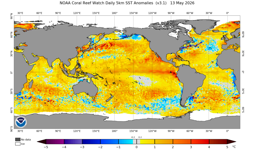
With the necessary sea surface temperatures (SSTs) of 26.5°C or warmer (~80°F) now in place for the formation and growth of such tropical cyclones, as these varying intensity storms are collectively known, the different direction winds with altitude that can disrupt formation also wane further every day, much more quickly than they do in the Atlantic this time of year. This leads to the ripe conditions of warm seas and light winds aloft in the eastern Pacific that feed such early season tropical cyclone evolution.
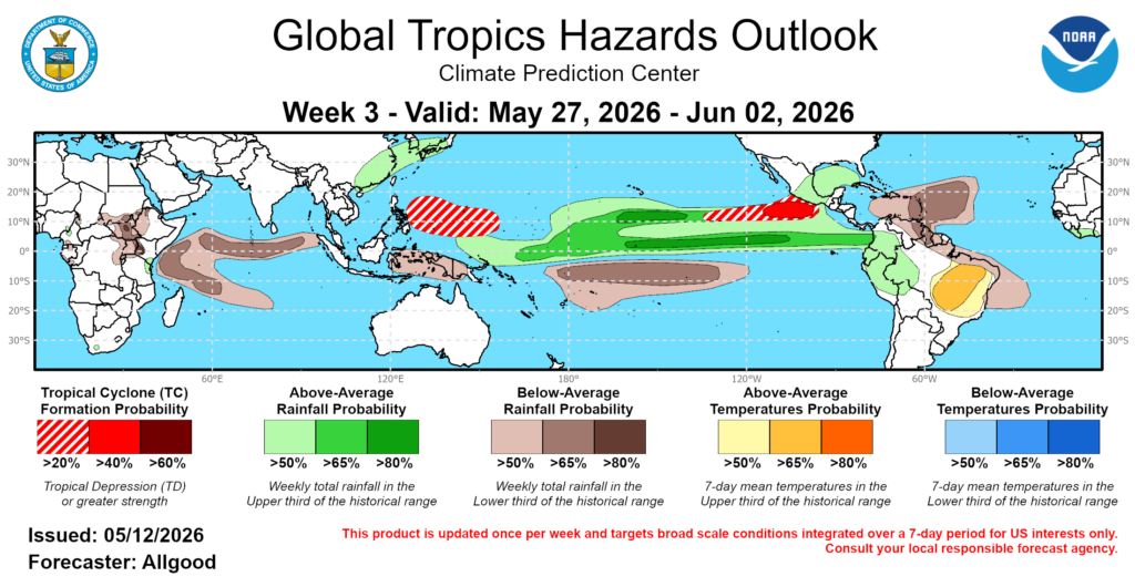
In fact, the Climate Prediction Center in its 3-week Global Tropical Hazards Outlook shows odds greater than 40% for development of a tropical disturbance south of Mexico around the end of May. With SSTs already greater than 30°C (86°F), any such disturbance has the potential to develop into the season’s first named tropical storm with steady winds of at least 39 mph and higher gusts, and maybe even into a hurricane with sustained winds of at least 74 mph with higher gusts.
All that a tropical cyclone needs to get going is a trigger—a disturbance of some kind in the atmosphere, or a dying cold front that provides a focus, or more likely a wave of lower pressure in the atmosphere—that already is prompting showers and thunderstorms, to take advantage of the heat given off by a percolating ocean to grow.
Heat feeds the thunderstorms, and Earth’s spin organizes them into swirling masses that devour and use that heat and rising humidity from the ocean’s surface to explode into formidable and dangerous storm systems in the nearly still air above.

But a storm before June, although possible, isn’t favored in the eastern Pacific basin, according to climatology. Based on the 30-year climate period of 1991 to 2020, an average EPAC hurricane season has 15 named storms, 8 hurricanes, and 4 major hurricanes. The first named storm typically forms in early to mid-June, the first hurricane in late June, and the first major hurricane with sustained winds greater than 110 mph in mid-July.
That can change, however, depending on whether an El Niño or La Niña is present—and what could be a monster El Niño that is increasingly being predicted for this year by climate models could significantly up these numbers—as NOAA’s first seasonal hurricane outlook now shows—by a lot. These tropical ENSO entities present as anomalously warm or cold water, respectively, along the equator in the eastern Pacific Ocean. And both can alter conditions that either favor or curtail the formation of tropical storms and hurricanes in the basin.
Latest El Nino forecast through October, including the C3S models that updated this morning: pic.twitter.com/mdxt34w70Y
— Zeke Hausfather (@hausfath) May 11, 2026
El Nino’s formation is highly favored this year, with its warmer-than-average sea surface temperatures nearly reaching the +0.5°C anomaly threshold already. An El Niño Watch is in effect, and the warm-water anomaly is expected by June. But the SSTs along the equator will continue to warm substantially thru the summer, and are forecast to far exceed the threshold of +2.0°C to make this year’s event a “Super” El Niño. Some climate models are even projecting SSTs to peak between 3°C and 4°C above average by the end of this year, which would near or surpass the record +3.5°C El Niño SST anomaly set almost 150 years ago in 1877.
While such increased SSTs are known to supercharge the eastern Pacific’s hurricane season, that extreme level of ocean surface warmth is mostly unknown in its effect on not only the region’s hurricane season but also global weather, which El Niño substantially affects.
El Niño tends to enhance the numbers and intensity of tropical cyclones in the eastern Pacific by keeping both wind shear and the trade winds lower than usual, the latter of which allows SSTs north of the equator to warm well above normal as well. An above-average-season in numbers of observed storms, hurricanes, and especially major hurricanes is expected.
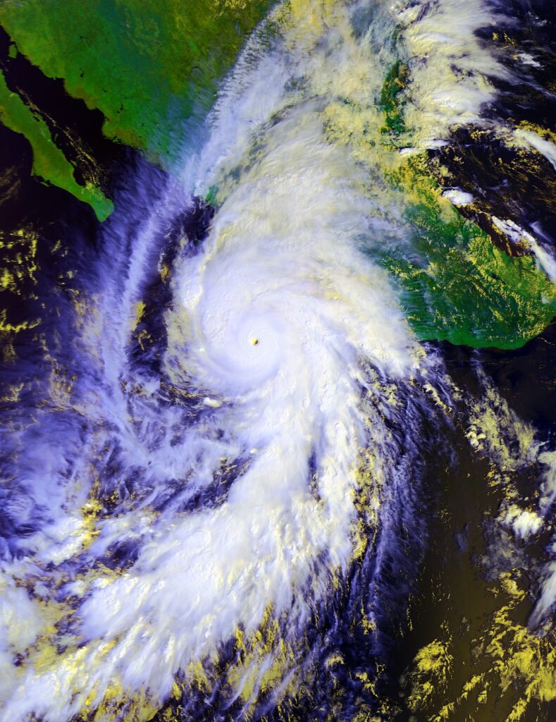
During the last three Super El Niños that began in 2015, 1997, and 1982, the average numbers in the eastern Pacific those years were 19, 11, and 7, respectively for named storms, hurricanes, and major hurricanes—all within the outlooked ranges from NOAA. And in 1982, there were 23 named storms—one more than NOAA’s projection; in 2015 there were 13 hurricanes and 9 major hurricanes, including Patricia (above), which became the strongest hurricane on record in not only the eastern Pacific basin but also the Western Hemisphere, and was the first operationally advised Category 5 Hurricane by the National Hurricane Center with sustained winds over 200 mph.
| EASTERN PACIFIC | HURRICANE | SEASON | NAMES |
| Amanda | Genevieve | Marie | Trudy |
| Boris | Hernan | Norbert | Vance |
| Cristina | Iselle | Odalys | Winnie |
| Douglas | Julio | Polo | Xavier |
| Elida | Karina | Rachel | Yolanda |
| Fausto | Lowell | Simon | Zeke |
While it’s impossible to predict whether an even more intense Super El Niño than in 2015 will produce another epic 200+ mph hurricane, it remains to be seen just how wild the 2026 eastern Pacific hurricane season will be.