Key messages from "The Value of Precipitation Forecasts to Anticipate Floods," by Tim Busker (Vrije Universiteit Amsterdam), Bart van den Hurk, Hans de Moel, and Jeroen C. J. H. Aerts. Published online in BAMS, March 2025. For the full, citable article, click the link above.
Recent disastrous floods triggered by extreme rainfall, such as the 2021 western Europe floods, the 2023 Emilia-Romagna floods, and the 2022–23 California floods highlight the urgent need to scale up early actions. While much investment over recent decades has been focusing on forecasting rainfall and floods, the science behind the translation of early warning to early actions is running behind. This knowledge gap leaves crucial questions open in the decision-making process: what is the best moment to release an early warning and trigger early action? How do you determine if forecasts are skillful enough to trigger action on a certain lead time? And do you implement expensive actions, or only cheap ones? These are questions that operational forecasters and decision-makers face. The answers to these questions go beyond forecast skill alone, and also largely depend on the actions themselves, especially their costs and the damages they prevent (the so-called cost–loss ratio).
With our research, we asked the question: What is the value of precipitation forecasts in anticipating local flood events, such as the 2021 floods in northwestern Europe?
To answer this, we used the potential economic value (PEV) theory to calculate the value of precipitation forecasts over Europe, based on lead-time dependent forecast skill and early action characteristics. We calculate the forecast value for ECMWF’s extreme forecast index (EFI) and shift of tails (SOT) forecasts, two widely used operational early warning rainfall indicators. First, we analyzed the forecast skill of both EFI and SOT over 8 years in predicting extreme rainfall events (>5-year return period). Subsequently, we included best estimates of the costs (C) and prevented damages (L) of emergency flood measures. We used these estimates to calculate the long-term value (PEV) of these early actions for >400 warning thresholds and determined the optimal trigger thresholds, with the highest forecast value, over all of Europe.
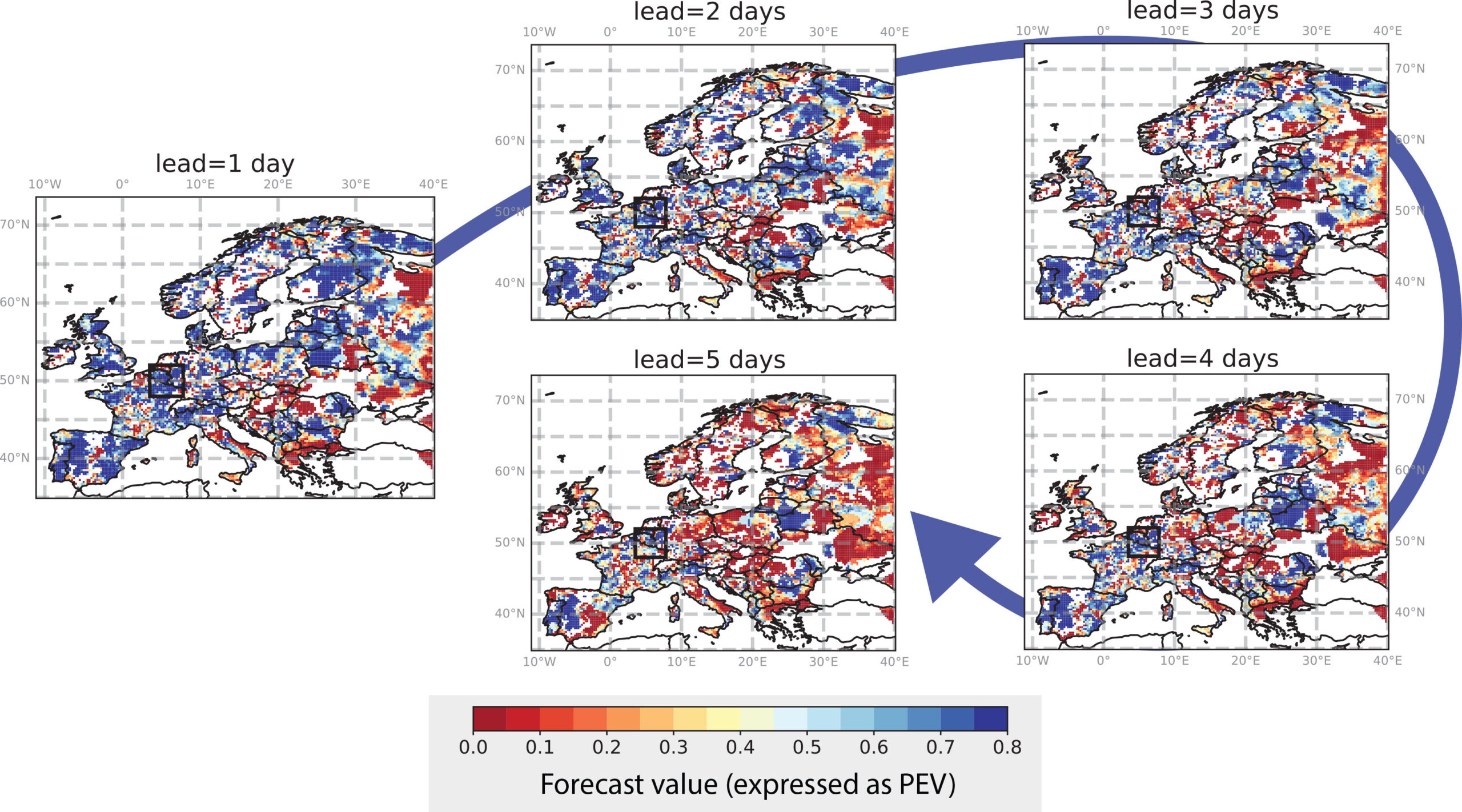
We found that both EFI and SOT forecasts can be used effectively to trigger early action and anticipate local floods across most of Europe. Therefore, they can reduce the impacts of pluvial (rainfall-induced) flood events. However, forecasts with a lead time of more than 3 days are in many areas not skillful enough to trigger effective early actions. Surprisingly, while the EFI is most widely known and used, the SOT often provides more detailed, skillful, and useful predictions.
A unique feature of this study is that we applied the optimal warning thresholds, as found in the long-term PEV analysis, to a specific event. We show that both the EFI and SOT forecasts widely exceeded the derived optimal warning thresholds a couple of days ahead of the severe 2021 floods in northwestern Europe. Most striking is the spatial accuracy of the SOT forecasts in the days ahead of the event. With a 1-day lead time, the SOT forecasts accurately pointed to the Ahr catchment, providing strong indications of the disaster that unfolded there. These highly exceptional SOT warning values enabled a preparation window of at least 16 hours to prepare for the incoming disastrous precipitation in the Ahr valley and its surrounding areas.
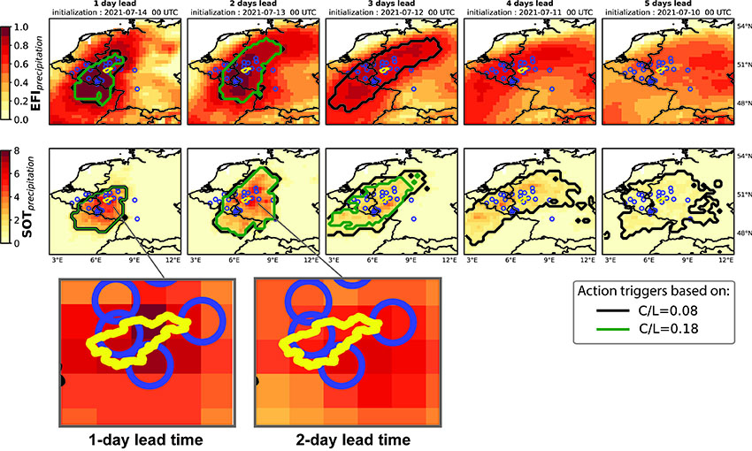
These results emphasize the high value of the EFI and SOT warnings for triggering early action. We encourage operational forecasters to continue using these indicators to trigger preparedness actions. National meteorological and hydrological services can use this framework to determine their own optimal warning thresholds for their service area, tailored on both the costs (C) and prevented losses (L) of the early actions, and the forecast skill. This allows decision-makers to incorporate objective and tailored thresholds for triggering early actions. We call for further testing the early-warning indicators on more high-impact events, including on other continents such as North America. Let’s move beyond forecast skill and include early actions in the equation, to aid operational decision-making processes and increase the effectiveness of early warnings and actions.
METADATA
AMS: What would you like readers to learn from this article?
Tim Busker (Vrije Universiteit Amsterdam): A gap exists between early warning and early action, in research, practice, policies, everywhere. This is partly because early actions are often not considered in science, where analyses stop at forecast skill metrics. In practice, we see that emergency and contingency plans for floods sometimes include warning levels, but that a clear protocol stating which actions should be triggered when is often missing. This disconnect strongly reduces the effectiveness of early warning systems and leads to avoidable damage and fatalities. We hope that people reading the article are convinced of the importance of analyses capturing early actions and their characteristics, such as with the PEV method.
AMS: How did you become interested in the topic of this article?
TB: During the 2021 western Europe floods, I was on holiday in Austria and thus not at work. When seeing the unprecedented impacts of the flood on the news, I was wondering: Was the event accurately forecast and did decision-makers have enough information to take the necessary actions? On my phone I quickly saw that ECMWF showed highly exceptional output, but many questions were of course still present. After the holidays, I continued my PhD about early-warning and early-action systems and decided to dive into the ECMWF forecasts. To my surprise, I quickly found out that the EFI and SOT forecasts showed extreme (and highly exceptional) outputs and that they showed a clear signal towards the impacted areas. That’s how this research started.
AMS: What got you initially interested in meteorology or the related field you are in?
TB: Since secondary school I had had a strong interest in disaster risk management, which at that time was triggered by an inspiring teacher. During my BSc and MSc studies, my passion for flood forecasting developed. As part of an internship at IHE Delft, I went to Indonesia to investigate flood risks and adaptation options, an experience which strongly contributed to my interest in the topic. My PhD promotors—Jeroen Aerts, Bart van den Hurk, and Hans de Moel—played a central role in the enthusiasm and dedication I still have for this field.
AMS: What surprised you the most about the work you document in your article?
TB: In general, the very high forecast value (PEV) we found for both EFI and SOT forecasts across massive parts of Europe. This shows that these indicators are very valuable for decision-makers working in flood preparedness. I remember the moment of making the first plots for the operational SOT forecasts for the 2021 floods to see how the record-breaking values pointed exactly to the Ahr catchment on a 1-day lead time. Unfortunately, over 100 people lost their lives in this catchment. This is a very small catchment of just 900 km2, so we were stunned to see the SOT forecasts being so incredibly accurate.
AMS: What was the biggest challenge you encountered while doing this work?
TB: This may be a bit of a boring answer, but it was related to the data size. We work with the university’s supercomputers, but even so, 8 years of daily forecasts with a lead time of 5 days, looped over 400 different warning thresholds, requires heavy computations. We had to upscale the computational resources multiple times to make it possible.
AMS: What’s next? How will you follow up?
TB: Although our research proved that the ECMWF meteorological forecasts are highly valuable and useful for early flood warnings, we want to extend the methodology to hydrological and hydrodynamic forecasts. This allows for detailed impact-based predictions of inundation extent, predicting which areas within a catchment are at risk. Finally, we can simulate the effectiveness of early actions in a new model, which also allows the inclusion of human behavior (e.g., trust in the forecasts). These efforts will lead to an improved understanding of early action for floods, and will eventually lead to more effective actions on the ground. Currently, we are collaborating with multiple stakeholders to set up projects around early flood warnings and actions. One of those organizations is the Water Board Limburg, with whom we are meeting to strengthen our collaboration on improving early flood warnings.