By Anthony Gianni Duarte et al.1

Rapid intensification (RI) of tropical cyclones (TCs) has become a concerning trend in recent years and has made hurricane forecasting increasingly difficult as a result. Several recent studies have been conducted suggesting an overall increasing trend in rapidly intensifying TCs across different ocean basins. Studies also found an increasing rate of intensification from Category 1 (CAT1) to major hurricanes (CAT3+) during the past 35 years. Probabilities of RI and rapid weakening (RW) also have both risen during the period 2000-18 compared to 1982-99, additional research found. However, tropical depressions (TDs) were not included in some studies, resulting in fewer samples and therefore missing many RI cases that initially began in the TD stage. Similarly, other studies only looked at CAT1-5 hurricanes with lifetime maximum intensity of at least CAT2 or CAT3, excluding TDs and tropical storms (TSs). With these deficiencies in mind, we analyzed 40 years of TC best track data (1982-2022) to determine the long-term trends of TC intensity change that included TCs from all initial intensity stages (e.g., TD, TS, and all hurricanes from CAT1 to CAT5) and all global TC-prone basins.

We classified TC intensity change into different categories including RI (of both 30 and 50 knots), slowly intensifying (SI), neutral (N), slowly weakening (SW), and RW (of both 30 and 50 knots), and compared the trends of TC intensity changes in the Atlantic (ATL), East Pacific (EPA), Northwest Pacific (NWP), South Pacific (SPA), North Indian (NIO), and South Indian (SIO) basins. We determined that 6 of the 7 intensity changes across all global basins recorded significant results, with increasing values being observed in the highest intensity-change metrics, including RI by 30 knots (RI30) and 50 knots (RI50), as well as RW by 30 knots (RW30) and 50 knots (RW50).
Preliminary assumptions behind the increasing decadal trends in RI, pending further research, is that ambient conditions, such as sea surface temperatures and tropospheric moisture content, are becoming more favorable within the warming climate.

Similarly, RW could be attributed to a number of environmental parameters depending on a TC’s position relative to a specific inhibiting factor (such as wind shear or dry air), but explaining the proportional relationship between RW and RI may require a deeper analysis on the structural dynamics of these TCs, with processes such as eyewall replacement cycles presumably occurring more frequently given the higher propensity for TCs to undergo RI.
Our conclusions, specifically on the RI of tropical cyclones, will drastically improve hurricane modeling and forecasting, giving meteorologists a better understanding on the exact factors that cause RI and how to accurately foresee it with adequate lead time.
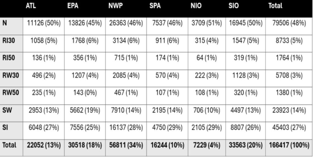
- Anthony Gianni Duarte (Florida International University), Haiyan Jiang, and Oscar Fernando Guzman, “Global Trends of Tropical Cyclone Intensity Change,” presented as a poster at the AMS 37th Conference on Hurricanes and Tropical Meteorology, March 30-April 3, 2026, in San Diego, California. ↩︎