by Stephen R. Guimond1
Extratropical cyclones frequently contain multibanded cloud and precipitation structures that can strongly influence the distribution and intensity of precipitation. This is especially problematic in the winter months when these multibands can produce large snowfall rates, causing travel chaos and potential loss of life. Although these bands are commonly observed by radar and satellite instruments, the dynamical processes responsible for their organization and characteristic spatial scales remain poorly understood. In particular, previous studies have often attributed multibanded structures to atmospheric gravity waves. This research investigates the dynamics responsible for multibanded structures using a detailed case study from the NASA Investigation of Microphysics and Precipitation for Atlantic Coast-Threatening Snowstorms (IMPACTS) field campaign. The analysis provides new evidence that the dominant multibands in this case were not gravity waves but instead resulted from a shear-driven hydrodynamic instability associated with the storm’s upper-level outflow.
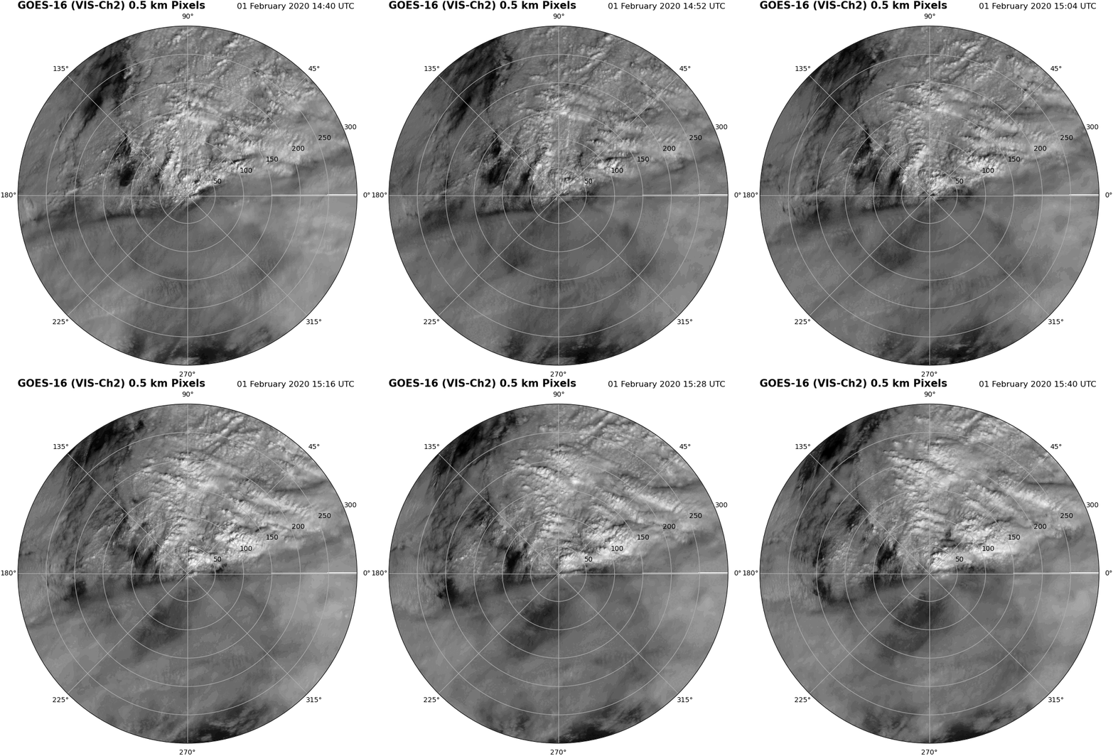
The study focuses on an extratropical cyclone observed on 1 February 2020 as part of the IMPACTS campaign. The low-pressure system developed off the North Carolina coast at 1200 UTC and rapidly intensified, deepening by 7 hPa over six hours as it accelerated northeastward across the Atlantic. High-resolution visible satellite imagery from the Geostationary Operational Environmental Satellite (GOES) revealed multiple narrow bands of enhanced cloud reflectance extending north and northeast of the cyclone center, as well as clusters of convective cells closer to the storm core. These observations provided an opportunity to examine the structure and dynamics of multibanded precipitation within a rapidly developing cyclone.
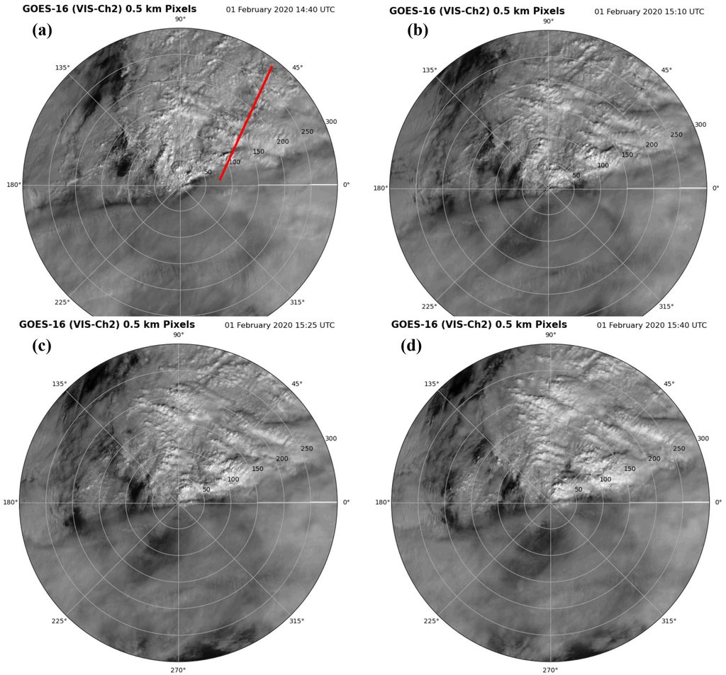
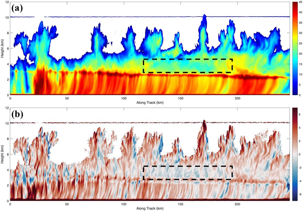
The investigation combined satellite observations, airborne radar observations, wavelet analysis, and numerical simulations. Wavelet analysis was applied to the high-resolution GOES-16 imagery to quantify the characteristic spatial scales of the observed cloud bands. This analysis identified a dominant wavelength of approximately 30 km, with a secondary peak between 15 and 20 km. Airborne radar observations collected during IMPACTS flights provided detailed measurements of the three-dimensional precipitation and cloud structure. These observations revealed deep convection near the cyclone center and narrow, elevated reflectivity bands farther from the center that were spatially associated with the multibanded cloud features.
Numerical simulations were then used to reproduce the observed multibanded structures to investigate their dynamical origin. Because the simulations provided a complete representation of the atmospheric flow, they allowed the relationship between the bands and the storm’s wind, thermodynamic, and secondary circulation structures to be examined in detail. Intrinsic phase speeds and polarization relationships were calculated to determine whether the simulated perturbations possessed the characteristics expected of atmospheric gravity waves. The simulations were also analyzed in terms of the vertical wind shear, structure of the secondary circulations, and Richardson number to assess the potential for hydrodynamic instability.
The results indicate that the dominant multibands were inconsistent with gravity-wave dynamics. Although gravity waves were present, they were primarily confined to the low- and midlevels and were generated by convection near the cyclone center. They did not produce the strong perturbations observed in the mid- to upper levels where the dominant multibanded structures were located. Instead, the multibands were found to be manifestations of inflection-point instability. The instability was associated with counterrotating secondary circulations and a strong vertical wind-shear profile near the upper-level outflow. In this region, low Richardson numbers also indicated conditions favorable for shear-driven instability. The resulting hydrodynamic instability generated organized perturbations that corresponded to the observed multiband structures and their characteristic spatial scales.
These findings provide a new interpretation of multibanded structures in extratropical cyclones by demonstrating that shear-driven hydrodynamic instability can produce prominent cloud and precipitation bands without requiring gravity waves to serve as the primary organizing mechanism. This distinction is important because it provides a different physical framework for understanding the development, structure, and evolution of multibanded precipitation in rapidly developing cyclones.
The results also motivate several avenues for future research. Additional observational and numerical studies are needed to determine how frequently inflection-point instability occurs in extratropical cyclones, the structure of the secondary circulations that result from the instability, including how they extend to the surface, and how these characteristics vary among different storm environments. In addition, further studies are needed to address how the instabilities interact with convection, gravity waves, and the larger-scale cyclone circulation. A broader examination of these processes could improve our understanding of the dynamical mechanisms governing precipitation organization and potentially contribute to improved prediction of multiband structure and intensity in high-impact winter storms.
A Brief Conversation
with the Author

AMS Headlines: What would you like readers to learn from this article?
Stephen Guimond, Hampton University: The atmosphere is a remarkably complex fluid, with a rich array of interactions among dynamical, thermodynamic, and microphysical processes. In this study, interactions among deep convection, hydrodynamic instabilities, and cloud microphysical processes contributed to the formation and evolution of the multibands that were observed.
When readers observe multiple bands of clouds or cloud streets in an extratropical cyclone, particularly in visible satellite imagery, they should consider the possibility that these structures are manifestations of a hydrodynamic instability generated by vertical wind shear. That interpretation contrasts with the common assumption that such bands are governed and organized by gravity waves. In the case examined here, gravity waves were present, but they did not explain the dominant multibanded structures. Instead, the observations and simulations showed that the bands were associated with a shear-driven hydrodynamic instability (primarily inflection-point instability). This provides a new perspective for interpreting the origins of multibanded structures in extratropical cyclones and highlights the importance of considering the full range of interacting atmospheric processes when diagnosing their formation.
AMS Headlines: How did you become interested in the topic of this article?
SG: While working at NASA Goddard Space Flight Center, I was part of the NASA IMPACTS science team, whose goals included understanding the fundamental mechanisms governing the formation, evolution, and predictability of snow multibands. I spent several weeks each winter at NASA Wallops Flight Facility supporting the field campaign and became particularly interested in the real-time observations being collected by the research aircraft, especially the airborne radar measurements. Watching these observations come in during the field campaign sparked my interest in using them to investigate the underlying dynamics of snow multibands.
My research background had focused heavily on hurricane dynamics, so I was intrigued by the opportunity to apply the physical concepts and analytical approaches I had developed in that area to a different type of atmospheric system. This project provided an opportunity to expand my research into a new area while drawing on my existing expertise in atmospheric dynamics.
AMS Headlines: What got you initially interested in meteorology or the related field you are in?
SG: There were a variety of things that helped to carve out my career path, but initially as a child it was fear. I remember being very afraid of severe weather and I got exposed to a fair amount of it growing up in the Midwest (Kansas and Illinois). I remember one instance where I was at a movie theater with my brother and someone rushed in and yelled that a tornado was coming. We all exited the theater and were told to kneel and cover our heads with our hands. The tornado never actually hit the movie theater, but that sort of thing happened every once in a while, to stimulate my fear.
Later, during my undergraduate and graduate studies, I became increasingly interested in mathematics, physics, and computer science. I came to appreciate that meteorology is deeply rooted in all three disciplines, even though the general public may not realize just how much mathematics, physics, and computational science underpin the field. Discovering this quantitative and interdisciplinary foundation gave me a deeper appreciation for meteorology and made me feel that I was part of a rigorous scientific discipline—one that I could genuinely be proud to pursue.
AMS Headlines: What surprised you the most about the work you document in this article?
SG: I was pleasantly surprised by how well the model simulations were able to reproduce the multibands observed in the satellite and airborne radar measurements. Although there were differences in the detailed structure and evolution of the bands in both space and time, the simulations captured their overall organization and location reasonably well. This provided confidence that the model was representing the fundamental dynamical processes responsible for the multibands, while also highlighting areas where further improvements are needed. Even in a field experiment with extensive observations, models remain essential for providing context and interpretation, as well as a sandbox in which physical processes can be isolated and examined.
Future work should focus on improving the fidelity of the simulated structures at finer spatial and temporal scales. This will require continued improvements to the model numerics and, in particular, to the subgrid-scale parameterizations governing cloud microphysics and turbulence. Improving these aspects of the model should help better capture the detailed structure and evolution of multibanded precipitation systems.
AMS Headlines: What was the biggest challenge you encountered while doing this work?
SG: I began this project in 2020 while working at NASA Goddard Space Flight Center. I was not satisfied with my initial results, and I realized that I needed to rethink how I was approaching the problem. After discussions with a trusted collaborator, I was able to step back and approach the problem with a fresh perspective. This change in perspective ultimately proved to be an important turning point in the project.
At the same time, I was transitioning to a new position as an Associate Professor in the Department of Atmospheric and Planetary Sciences and Director of the Severe Weather Research Center at Hampton University. A large portion of the final published work was completed during the first few years of my new faculty position. Completing a sole-author paper while adapting to a very different job, moving with my family to a new area, developing, and teaching several new courses, writing research proposals, and recruiting and advising students was a significant challenge. Much of the work on the paper was completed during nights, weekends, and holidays.
Despite these challenges, the experience ultimately strengthened both my persistence and my expertise in atmospheric dynamics. One particularly rewarding aspect of the project was that, during the analysis, I derived the intrinsic phase-speed and polarization relationships from first principles for several different types of atmospheric waves. This work not only helped me resolve a central scientific question in the paper, but also directly informed my graduate course on Waves and Instabilities. In this way, the challenges of the research ultimately contributed to both my scientific development and my teaching.
I have always believed that it is more important to focus on the quality and significance of a scientific contribution rather than simply on the number of papers published. This project required considerably more time and persistence than I initially anticipated, but I believe that investment ultimately resulted in a stronger and more meaningful scientific contribution.
AMS Headlines: How will you follow up?
SG: The natural next step is to take the new, fundamental understanding developed in this paper and test it across a much broader range of cases from the IMPACTS campaign. Such a study would help determine how general these findings are and under what environmental conditions the identified mechanisms are most important. I believe this would be an excellent project for a graduate student, and I am currently exploring funding mechanisms to support this research and recruit interested graduate students.
We also have a near-real-time forecasting system at the Severe Weather Research Center at Hampton University that initializes the background atmospheric state using thermodynamic information derived from satellite observations. This system provides an excellent framework for identifying and analyzing new cases and for developing standardized procedures to test the findings of this paper across a larger population of storms. Ultimately, this could provide a pathway toward determining how broadly these dynamical mechanisms apply to extratropical cyclones and how they may influence the organization of clouds and precipitation.

“I love being physically active and spending time with family.”
- Key messages from “Shear-Driven Instabilities as the Origin of Multibanded Cloud and Precipitation Structures in an Extratropical Cyclone,” by Stephen R. Guimond (Hampton University). Published in the Journal of the Atmospheric Sciences, July 2026. ↩︎